1) Geographic Frame Coordinate System


地固坐标系
1.
But the data of the file provide with the Geographic Frame Coordinate System , so the change of the Global Total Electron Content (IGTEC) maps are certainly influenced by the factors of the earth rotation and the earth pole moving etc.
然而这些数据是在地固坐标系中给出的,因此其中的全球电离层TEC图像数据的变化必然会受到地球自转、极移等因素的影响。
2) ECEF


地心地固坐标系
1.
We studied the biases estimation and sensor registration of sensor network by using Earth Centered Earth Fixed(ECEF) coordinates as unified coordinates.
采用地心地固坐标系作为统一坐标系,研究了多传感器组网中的配准估计问题。
2.
Taking Earth Centered Earth Fixed(ECEF) coordinate as common grid,this paper discusses bias estimation in 3-D sensor network according to the superposition of the same target in different sensors,the linearized measurement equation of range,range gain,azimuth and elevation deviation of each sensor can be derived via the first order Taylor series expansion.
采用地心地固坐标系作为统一坐标系,研究了3-D传感器组网中的偏差估计问题,根据同一目标位置在各个传感器探测中的迭合条件,运用一阶泰勒展式推导出各个传感器的距离、距离增益、方位角、仰角偏差的线性化公式,利用最小二乘法在线估计出各个偏差量,并实时进行修正,仿真结果验证上述方法的有效性。
3) earth centered fixed coordinate frame


地心固连坐标系
1.
An analysis model based on the earth centered fixed coordinate frame is introduced, for achieving a quantitative analysis of Doppler shift characteristics over non-GEO satellite channels.
为了定量分析非静止轨道卫星信道的多普勒频移特性 ,引入一种基于地心固连坐标系的分析模型 ,经近似 ,该模型与地面接收终端的地理坐标无关 。
4) pseudo body-fixed system


准地固坐标系
5) Earth centered fixed


地球中心固定坐标系
补充资料:地平坐标系
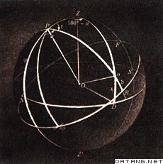
| 地平坐标系 horizontal coordinate system 一种天球坐标系。以观测者为天球中心,过天球中心并与过观测者的铅垂线相垂直的平面称为地平面,它与天球相交而成的大圆称为地平圈。地平面是地平坐标系的基本平面。过观测者的铅垂线向上延伸与天球的交点称为天顶,向下的交点称为天底 ,天顶是地平圈的极 ,也是地平坐标系的极。经过天顶的任何大圆称为地平经圈或垂直圈;与地平圈平行的小圆称为地平纬圈或等高圈。过北天极的地平经圈称为子午圈,它与地平圈相交于北点和南点;与子午圈相垂直的地平经圈称为卯酉圈,它与地平圈相交于东点和西点。通常取北点或南点作为主点。从北点起沿地平圈顺时针向量到过天球上一点的地平经圈与地平圈的交点,这一弧长为地平坐标系的经向坐标,称为地平经度或方位角,从0°到360°;方位角也有从南点起向东向西从 0°到180°计量。从地平圈,沿过该点的地平经圈量度至该点的大圆弧长为纬向坐标,称为地平纬度或高度,从 0°到±90°,向天顶为正,向天底为负;高度的余角,即从天顶量度至该点的大圆弧长称为天顶距。
由于因日视运动,天体对于同一地点的地平坐标不断变化,另一方面,对于不同的观测者,由于铅垂线的方向不同,有不同的地平坐标系,在同一瞬间同一天体的地平坐标也就不同。因此,记录天体位置的各种星表不能采用地平坐标系。 |
说明:补充资料仅用于学习参考,请勿用于其它任何用途。
参考词条
