2) Yili River Valley

伊犁河谷
1.
Environmental Analysis and Comprehensive Evaluation of Ecotourism Resources in Yili River Valley;
伊犁河谷生态旅游资源环境分析及评价
2.
On Identity of Eco-tourism and Product Design in Yili River Valley;
伊犁河谷生态旅游形象定位及产品设计
3.
In the last few years,the tourism development is quite rapid in Yili river valley,but tourism development gets behind with others areas by a long way.
近年来伊犁河谷旅游业虽取得了很大的发展,但与相邻地区相比,差距明显,文章拟通过对伊犁河谷旅游资源的概念性评价和旅游资源整合条件分析,提出旅游整合开发的思路构想,为区域旅游业竞争力的提升和经济一体化的实现有所裨益。
3) Yili Valley
伊犁河谷
1.
Extreme Weather and Climate Change over Yili Valley in Spring and Summer
伊犁河谷春夏季极端天气气候的变化分析
2.
Study on the tourism production exploitation in Yili Valley of Xinjiang
新疆伊犁河谷地区旅游产品开发的战略研究
3.
Yili Valley of Xinjiang was taken as a sample to sort out regional tourism resources classification.
文中以新疆伊犁河谷地区为案例,梳理区域旅游资源类型,在此基础上分析了竞争型旅游资源类型和旅游资源市场竞争力,并以竞争型资源为主要吸引物提出旅游资源的空间区域整合开发方案。
4) Ili River valley
伊犁河谷
1.
Investigation and Analysis on Cold Damage of Apple in Ili River Valley
伊犁河谷苹果冻害调查分析
2.
Investigation on Legume Plants Resources in the Ili River Valley
伊犁河谷地区豆科植物资源的初步研究
3.
The erosion traits of melted- snow were studied during spring from March 3 to March 10,2009,at Ili River valley slope land.
采用坡面径流小区试验法,于2009年3月3~10日,对伊犁河谷缓坡地的春季融雪侵蚀特征进行了系统研究。
5) Ili valley
伊犁河谷
1.
Phylogenetic analysis of Borna disease virus in Ili valley,Xinjiang
新疆伊犁河谷博尔纳病病毒种系发生学分析
2.
Based on interpreting Landsat TM remote sensing images of Ili River Valley from 2000 and 2005,the article analyze the present situation,dynamic change and its character of LUCC,the result show that the extent of land utilization is low,the land utilization process is on the developing phrase,the variation of LUCC is distinct,and the eco-environment problem is evident increasingly in Ili Valley.
解译2000和2005年伊犁河谷的Landsat TM遥感影像,分析和探讨土地利用-土地覆盖现状和动态变化及其特征。
3.
The ecological function division determinated ecological system service function and economic development direction of every zone,so laid solid foundation for sustainable development of Ili valley.
伊犁河谷生态功能区划以伊犁河谷生态现状和《生态功能区划暂行规程》为依据,采用区域生态环境敏感性、生态系统服务功能重要性以及生态环境特征的相似性和差异性分析和遥感及地理信息系统技术,进行相关资料的数字化处理,利用计算机图形空间叠置法,按生态功能分区的等级体系,把伊犁河谷划分为2个生态亚区,5个生态功能区。
6) Inversion belt
伊犁谷地
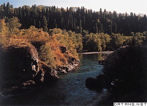
补充资料:伊犁河
| 伊犁河 位于天山山脉西段。上游在中国新疆维吾尔自治区西部。长约440千米,流域面积5.5万平方千米。上游有三源:特克斯河、巩乃斯河、喀什河。特克斯河是主源,出汗腾格里峰北坡,东流与巩乃斯河汇合后称伊犁河。西流至雅马渡有喀什河流入。以下进入宽阔的河谷平原,河床宽大,支汊和沙洲众多,下游在接纳了支流霍尔果斯河后流入哈萨克斯坦,最后注入巴尔喀什湖。河水由冰雪融水和雨水补给。春汛连结夏汛,汛期长,径流量年际变化较小,有利于农业灌溉。干流下游每年5~10月可通航船只。
|
说明:补充资料仅用于学习参考,请勿用于其它任何用途。
参考词条