1) trigonometric leveling with distance measurement


测距三角高程
1.
When completed river crossing leveling by means of trigonometric leveling with distance measurement, there are two types of observed values.
采用测距三角高程法进行跨河水准测量 ,可以不量取仪器高 ,但观测值中有两类不同的观测量。
2) Trigonometric Leveling Method of Distance Measuring


测距三角高程法
3) trigonometric leveling of vertical angle measurement and slope distance measurement type


角距同测三角高程测量
4) range finding trangle height survey


测距三角高程测量
5) the EDM trigonometric leveling


光电测距三角高程测量
1.
According to the principle of the spherical geometry, this paper approaches the principle of the EDM trigonometric leveling of leveling type.
从球面几何学的原理出发,探讨了水准式光电测距三角高程测量的原理,推导出了光电测距三角高程测量的严密计算公式,给出了水准式光电测距三角高程测量的实用计算公式。
6) subtend trigonometric leveling


对向测距三角高程
补充资料:三角高程测量
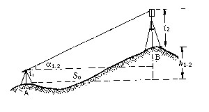
| 三角高程测量 trigonometric leveling 通过观测两点间的水平距离和天顶距(或高度角)求定两点间高差的方法。它观测方法简单,不受地形条件限制,是测定大地控制点高程的基本方法。 三角高程测量的基本原理如图,A、B为地面上两点,自A点观测B点的竖直角为α1.2,S0为两点间水平距离,i1为A点仪器高,i2为B点觇标高,则A、B两点间高差为 h1.2=S0tga1.2+i1-i2
上式是假设地球表面为一平面,观测视线为直线条件推导出来的。在大地测量中,因边长较长,必须顾及地球弯曲差和大气垂直折光的影响。 为了提高三角高程测量的精度,通常采取对向观测竖直角,推求两点间高差,以减弱大气垂直折光的影响。 |
说明:补充资料仅用于学习参考,请勿用于其它任何用途。
参考词条
