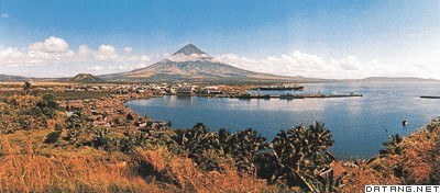
1) Luzon Island


吕宋岛
1.
Assemblage and provenance of clay minerals off the east of Luzon Island


吕宋岛东部海域黏土矿物组合特征及物源分析
2) Luzon arc


吕宋岛弧
1.
Epithermal mineralization in the Western margin of the Luzon arc:Lalab gold deposit;


吕宋岛弧西缘浅成低温热液成矿作用—以拉拉布金矿床为例
3) Northwest of Luzon Island


吕宋岛西北海域
1.
Analysis of the Structures and the Mechanisms of the Cyclonic Eddies to the Northwest of Luzon Islands
吕宋岛西北海域气旋式涡旋的结构及其形成机制
4) Luzon Strait


吕宋海峡
1.
Dynamics of eddy-induced Kuroshio variability in Luzon Strait;


中尺度涡旋影响吕宋海峡黑潮变异的动力机制
2.
Statistics of the Mesoscale Eddies on Both Sides of the Luzon Strait;


吕宋海峡两侧中尺度涡统计
3.
A numerical study on interannual variations of Luzon Strait transports;


吕宋海峡输送年际变异数值研究
5) Viburnum luzonicum


吕宋荚蒾
1.
Influencing Factors of the Stability of Red Pigment in Viburnum luzonicum Rolfe Fruits;


吕宋荚蒾果红色素稳定性的影响因子
6) Luzon Cold Eddy


吕宋冷涡
1.
Referenced to relative literatures and MarineAtlases of Hydrology,the authors illustrated the distributions of spatial,seasonal and therules of varieties of Luzon Cold Eddy.
5°网格进行温盐计算统计分析,制作了逐月平面、断面分布图的基础上,参考相关文献和海洋水文图集,阐明了吕宋冷涡的空间、季节特点及其变化规律。
2.
Luzon Cold Eddy which is one of the two seasonal cyclonic eddies in the South China Sea also originates there.
吕宋岛西北海域受到局地风应力和黑潮的共同作用,使其成为南海海洋涡旋的多发地带,也是南海两大季节性气旋式涡旋之一的吕宋冷涡形成区。
补充资料:吕宋岛
| 吕宋岛 Luzon Island 菲律宾面积最大、人口最多的岛屿。位于菲律宾群岛北部。面积10.5万平方千米,约占全国面积的35%。人口约2400万,约占全国人口的1/2。主要居民为他加禄人和伊洛克人,北部和东北部山区有矮黑人和其他少数民族。地势北高南低,2/3以上为山地、丘陵,山脉南北纵列。平原较少,以中西部中央平原和东南部比科尔平原为最大,还有一些海岸平原和河谷低地。除高山地区外,气候炎热,雨量丰沛,年降水量达2000毫米以上。主要河流有卡加延河、邦板牙河、巴士格河等。植被以热带雨林和热带季雨林为主。海岸线曲折,多港湾。矿产有金、铬、铜、锰、锌、煤等。为全国经济中心。中央平原为全国重要粮食产区;南部和东南部是重要经济作物区,60%以上耕地种植椰子,其次是蕉麻;北部和西北部为烟草主要产区。全国一半以上的工业和大部分公路和铁路也集中于此。主要城市有马尼拉、八打雁、打拉、甲米地、黎牙买比和碧瑶等。
|
说明:补充资料仅用于学习参考,请勿用于其它任何用途。
参考词条
