1) near surface model

近地表模型
1.
The original near surface model can not obtain a satisfactory solution for the statics problem due to the limited uphole survey and poor exploration status.
B区块勘探程度低,微测井数量少,原有的近地表模型不能很好地解决资料处理中的静校正问题,给最终的处理结果带来影响。
2.
It is the key of static correction to build a proper near surface model and static correction treatment scheme and exactly eliminate influence of static correction.
建立一个合适的近地表模型以及静校正处理流程,较为准确地消除静校正量的影响是复杂地表地区静校正处理的关键。
2) near-surface model
近地表模型
1.
On account of relief height difference increasing,variable landforms and complex near-surface model,widely applied first arrival refraction statics at present is unable to meet precision prospecting demand.
随着地形高差增大、地貌单元多变、近地表模型复杂,目前被广泛应用的初至折射静校正的精度已无法满足精细勘探的要求。
3) near surface velocity model
近地表速度模型
5) 3D near-surface model
三维近地表模型
6) terrain model
地表模型
1.
View-dependent and multi-resolution simplification algorithm of a terrain model;
与视点相关的多分辨率地表模型简化算法
2.
This paper introduces in detail the relative theories and algorithms, such as simplification with threshold value of tilt angle and the real time continuous level of detail rendering of digital terrain models.
地表模型显示在虚拟现实中有着广泛而重要的作用。
补充资料:AutoCad 教你绘制三爪卡盘模型,借用四视图来建模型
小弟写教程纯粹表达的是建模思路,供初学者参考.任何物体的建摸都需要思路,只有思路多,模型也就水到渠成.ok废话就不说了.建议使用1024X768分辨率
开始
先看下最终效果

第一步,如图所示将窗口分为四个视图

第二步,依次选择每个窗口,在分别输入各自己的视图

第三步,建立ucs重新建立世界坐标体系,捕捉三点来确定各自的ucs如图
第四步,初步大致建立基本模型.可以在主视图建立两个不同的圆,在用ext拉升,在用差集运算.如图:
第五步:关键一步,在此的我思路是.先画出卡爪的基本投影,在把他进行面域,在进行拉升高度分别是10,20,30曾t形状.如图:
第六步:画出螺栓的初步形状.如图
第七步:利用ext拉升圆,在拉升内六边形.注意拉升六边行时方向与拉升圆的方向是相反的.
之后在利用差集运算
第八步:将所得内螺栓模型分别复制到卡爪上,在利用三个视图调到与卡爪的中心对称.效果如图红色的是螺栓,最后是差集
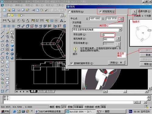
第九步:阵列
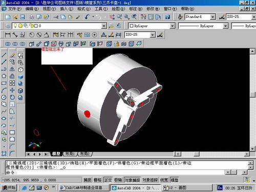
第10步.模型就完成了
来一张利用矢量处理的图片

说明:补充资料仅用于学习参考,请勿用于其它任何用途。
参考词条