1) remote sensing recognition models

遥感识别模型
2) pattern recognition of remote sensing
遥感模式识别
4) Remote sensing model
遥感模型
1.
Dual-source remote sensing model for estimating land surface evapotranspiration and its application in North China Plain;
陆面蒸散的双源遥感模型及其在华北平原的应用
2.
Based on the surface energy balance theory and in association of the real world data from the west of Jilin Province,the authors established a remote sensing model for estimating evapotranspiration for the study area.
基于地表能量平衡的基本理论,结合吉林西部实际资料,建立了吉林西部蒸散量估算的遥感模型。
3.
By means of observed soil moisture and the VT scattered chart,the drought grading indexes for the remote sensing model of soil moisture can be obtained for qualitative drought monitoring,and by means of the regression equation of soil moisture and VT,the quantitative soil m.
通过实测土壤湿度和TV的散点图,可以得到土壤墒情遥感模型的干旱等级指标,可用于干旱等级定性监测;通过建立土壤湿度和TV的回归方程,可进行土壤墒情定量监测。
5) remote sensing target recognition
遥感目标识别
1.
Based on the stationary wavelet based contourlet transform(SWBCT)and projection,a novel remote sensing target recognition method was put forward in this study.
方向信息提取与小样本问题是遥感目标识别与应用的瓶颈,基于平稳小波的Contourlet变换(Stationary Wavelet Based Contourlet Transform,简称SWBCT)与投影特征相结合,本文提出了一种新的遥感目标特征提取与识别方法。
6) Remote sensing image recognition
遥感图像识别
补充资料:AutoCad 教你绘制三爪卡盘模型,借用四视图来建模型
小弟写教程纯粹表达的是建模思路,供初学者参考.任何物体的建摸都需要思路,只有思路多,模型也就水到渠成.ok废话就不说了.建议使用1024X768分辨率
开始
先看下最终效果

第一步,如图所示将窗口分为四个视图

第二步,依次选择每个窗口,在分别输入各自己的视图

第三步,建立ucs重新建立世界坐标体系,捕捉三点来确定各自的ucs如图
第四步,初步大致建立基本模型.可以在主视图建立两个不同的圆,在用ext拉升,在用差集运算.如图:
第五步:关键一步,在此的我思路是.先画出卡爪的基本投影,在把他进行面域,在进行拉升高度分别是10,20,30曾t形状.如图:
第六步:画出螺栓的初步形状.如图
第七步:利用ext拉升圆,在拉升内六边形.注意拉升六边行时方向与拉升圆的方向是相反的.
之后在利用差集运算
第八步:将所得内螺栓模型分别复制到卡爪上,在利用三个视图调到与卡爪的中心对称.效果如图红色的是螺栓,最后是差集
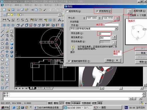
第九步:阵列
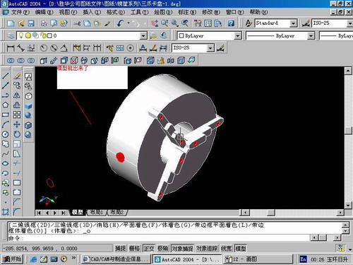
第10步.模型就完成了
来一张利用矢量处理的图片

说明:补充资料仅用于学习参考,请勿用于其它任何用途。
参考词条