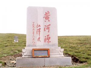
1) Yellow River Source Group


黄河源群
1.
The Yellow River Source Group(QH)stratigraphic unit was divided into four formations,i.


建立了青海东南部地区第四纪早更新世—全新世湖相地层单位—黄河源群(QH),黄河源群是由第四系下更新统野牛沟组(Qp1y)、中更新统鄂陵湖组(Qp2e)、上更新统大野马岭组(Qp3d)和全新统黑河乡组(Qhh)等4个组组成。
2) Huangshuihe Group


黄水河群
3) the source regions of the Yellow River


黄河河源区
1.
The annual average and rain season precipitation and yearly runoff of the source regions of the Yellow River were analyzed.
对黄河河源区多年平均和雨季降水量、年际径流量进行分析。
4) source area of the Yellow River


黄河源区
1.
Effects of neotectonic movement in the source area of the Yellow River, China on eco-environmental deterioration.;
黄河源区新构造运动对生态环境恶化的影响
2.
Discovery of early Pleistocene strata containing plants fossils in the source area of the Yellow River and significance;
黄河源区早更新世含植物化石地层的发现及意义
3.
The Hajiang saline pool in the source area of the Yellow River is located in Madoi County,Qinghai Province,at 36.
黄河源区哈江盐池被认为是古羌人从青藏高原东北部草原地带向成都平原迁徙和扩张的起点,而且得益于盐的开发和行运。
5) source region of the Yellow River


黄河源区
1.
Character analysis of ions in the source region of the Yellow River;


黄河源区水域离子特征分析
2.
Variations of soil temperature and water moisture of seasonal frozen soil with different vegetation coverages in the source region of the Yellow River,China;
黄河源区不同植被类型覆盖下季节冻土冻融过程中的土壤温湿空间变化
3.
Eco-environmental degradation in the source region of the Yellow River is a very serious ecological and socially economic problem.
生态环境退化是黄河源区所面临的重要的生态问题和社会经济问题。
6) headwater area of the Yellow river


黄河源区
1.
The reason for degeneration of the eco-environment advance trend in the headwater area of the Yellow river;
黄河源区生态环境恶化的地质原因及发展演化趋势
2.
Changes in water environment and their ecologicgeologic environmental effects in the headwater area of the Yellow River;
黄河源区水环境变化及其生态环境地质效应
3.
Since the 1990 s the aridity of the headwater area of the Yellow River has shown as increasing trend owing to the global change in the climate.
由于全球性气候变化,进入20世纪90年代后,黄河源区干旱化趋势加剧,出现大量中、小型湖、塘干涸,草场大面积退化和荒漠化,沼泽湿地失水严重,饱冰冻土向少冰冻土退化趋势明显,一些外流湖变为内陆湖等生态环境退化现象。
补充资料:黄河源

黄河源
黄河源位于青海的腹地。河源一为扎曲,二为约古宗列渠,三是卡日曲。扎曲一年之中大部分时间干涸,而卡日曲最长是以五个泉眼开始的 卡日曲最长是以五个泉眼开始的,流域面积也最大,在旱季也不干涸,是黄河的正源。古宗列曲,仅有一个泉眼,是一个东西长40公里,南北宽约60公里的椭圆形盆地,内有100多个小水泊,似繁星点点,又似晶莹的粒粒珍珠。
星宿海,历史上曾被用来表示整个黄河源头地区,实际上可以说是黄河出山东行后第一个加油站。这个“海”是一个盆形湿地,东西长约30公里左右,南北的距离较短,仅几公里至十几公里之间。说是“海”并非到处有水,而是在盆地中相对更低洼的地方聚集有水,拥有众多的大大小小水坑和水塘,多到用满天星斗来比拟也不显得过分。灌木有的长到一米高,鱼类繁多,水鸟成群,湖边的草滩上还有黄羊、野驴不时出现。
黄河源头之一卡日曲是以五个泉眼开始的,另一个源头是约古宗列曲,仅有一个泉眼。这是黄河的源头地区,旅游者在这里根本无法想象黄河之宗竟不是滔滔洪水,而是一股股细微的清泉和一片有许多砂砾野草的温林荒滩。
我国人民比较明确地认识黄河及其源头还是在唐代以后。因为从唐代起,中原人民同边疆少数民族间联系大大加强,特别是同居住在青藏高原上的吐蕃之间的往来日益频繁,而黄河源头是古代通往西藏高原的交通大道。
贞观十五年,文成公主嫁往西藏,吐蕃王松赞干布在黄河源头亲迎。公元八二一年,唐使刘元鼎出使吐蕃,还曾专门考察过黄河源头。黄河发源于颜喀拉山北麓各姿各雅山下的卡日曲河谷和古宗列盆地,分南北二源。两地海拔高程均在四千六百多米至四千八百多米之间,黄河源头被国家列为自然保护区。
说明:补充资料仅用于学习参考,请勿用于其它任何用途。