1) morphometric map


地貌形态示量图
2) landform
[英]['lændfɔ:m] [美]['lænd'fɔrm]


地貌形态
1.
The automatic classification of micro morphological landform has different systems and standards in different research fields.
系统分析了微观地貌形态的划分标准体系和方法,认为微观地貌形态的划分是宏观地貌形态划分的延续。
2.
Based on the climatic and landform data in the past 30 years in the southeast of Fujian Province, this paper points out that the development of dry climate depends not only on rainfall, but also on landform, soil, vegetable, and so on.
对福建东南沿海地区 30年的气象资料和地貌形态的分析表明 ,福建东南沿海地区干旱 ,以及沿海地区不同地段的干旱程度与地貌形态之间存在一定的联系 。
3.
The area lies in the pole permafrost zone, aeolian action and periglacial processes controlled the characteristics of modern landform.
并设计出适合拉斯曼丘陵区的地貌制图系统,分步骤对地貌形态的五大要素进行分析取舍。
3) topography
[英][tə'pɔɡrəfi] [美][tə'pɑgrəfɪ]


地貌形态
1.
The quantification study of watershed topography characteristics;


流域地貌形态特征量化研究进展
2.
Based on the basic fractal theory and GIS technique, the topographical fractal character of Chabagou watershed, which lies on loess plateau, is studied, the model and method that are used to calculate the fractal information dimension of the topographical fractal character of the watershed is put forward, and the fractal information dimension of the topography of Chabagou watershed is worked out.
本文基于分形基本理论和GIS技术,对地处黄土高原丘陵沟壑区第一副区的岔巴沟流域地貌形态分形特征进行了量化研究,提出了流域地貌形态特征分形信息维数的计算模型和方法,并依此获得了岔巴沟流域及各支流域的地貌形态特征分形信息维数。
4) morphological geomorphology


形态地貌
5) landscapes TUPU of Loess Plateau


黄土高原地貌形态图谱
6) Quantitative morphologic analysis


定量地貌形态分析
补充资料:冰川地貌
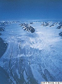
| 冰川地貌 glacial landform 由冰川的侵蚀和堆积作用形成的地表形态。地球陆地表面有11%的面积为现代冰川覆盖,主要分布在极地、中低纬的高山和高原地区。第四纪冰期,欧、亚、北美的大陆冰盖连绵分布,曾波及比今日更为宽广的地域,给地表留下了大量冰川遗迹。 冰川是准塑性体,冰川的运动包含内部的运动和底部的滑动两部分,是进行侵蚀、搬运、堆积并塑造各种冰川地貌的动力。但它不是塑造冰川地貌的唯一动力,是与寒冻、雪蚀、雪崩、流水等各种营力共同作用,才形成了冰川地区的地貌景观。 冰川地貌可分为冰川侵蚀地貌和冰川堆积地貌。冰川侵蚀地貌是冰川冰中含有不等量的碎屑岩块,在运动过程中对谷底、谷坡的岩石进行压碎、磨蚀、拔蚀等作用,形成一系列冰蚀地貌形态,如形成冰川擦痕、磨光面、羊背石、冰斗、角峰、槽谷、峡湾、岩盆等。冰川堆积地貌是冰川运动中或者消退后的冰碛物堆积形成的地貌,如终碛垄、侧碛垄、冰碛丘陵、槽碛、鼓丘、蛇形丘、冰砾阜、冰水外冲平原和冰水阶地等。
冰川地貌组合有一定的分布规律,从冰川中心到外围由侵蚀地貌过渡到堆积地貌。山岳冰川地貌按海拔高度可分为:雪线以上为冰斗、角峰、刃脊分布的冰川冰缘作用带;雪线以下至终碛垄为冰川侵蚀-堆积地貌交错带;最下部为终碛垄、冰川槽谷和冰水平原地带。 |
说明:补充资料仅用于学习参考,请勿用于其它任何用途。
参考词条
