1) geographic and geomorphic conditions

地形地貌条件
2) landform condition
地貌条件
1.
The type of landform is closely related to land use,and analyzing and evaluating the landform conditions is one of the basic tasks in land consolidation by adjusting measures to local conditions.
地貌类型与土地利用有着密切的联系,分析和评价地貌条件是因地制宜开展土地整理工作的基础工作之一。
3) terrain condition
地形条件
1.
Research of computer simulation for micro-irrigation system under different terrain conditions;
不同地形条件下微灌系统的计算机仿真研究
2.
A Flood Loss Prediction Model for insurance based on terrain condition and domain knowledge is proposed and implemented.
提出并实现了一种基于地形条件和领域知识的保险洪灾损失预测模型,根据数字高程模型生成地形及排水能力因子,利用神经网络模型的非线性映射能力进行仿真建模,并给出了在该模型中融合领域知识的方法。
4) topographic condition
地形条件
1.
The results show that the topographic conditions of the gas well greatly influence the calculation results of the individual risks, the distance between the upper limit isoline of acceptable risk and the well in different directions can reach 1 000 m.
结果表明,由于地形条件的影响,在气井周边不同方向的个人风险水平差异很大,可接受风险水平上限值等值线距井口的距离在不同方位上相差可达1000m,在对气井进行定量风险分析时必须充分加以考虑。
2.
The topographic condition of the gas well had a great impact on the calculation results.
结果表明,含硫气井所处的地形条件对硫化氢浓度场及受体致死概率计算结果影响很大:所选计算井其东、西、北三面地形平坦,以浅丘为主,南侧背靠海拔1 230 m的山峰,受井口南侧山峰的影响,北风下井口附近区域毒性负荷及受体致死概率最高,次高峰值处距井口约1 000 m,因此在对气井进行事故后果模拟及定量风险分析时必须充分考虑地形的影响。
3.
With the method of double-rings,we studied the effect of different topographic condition(slope gradient,slope position,slope exposures) and rainfall on soil infiltration.
采用双环法,研究不同地形条件(坡度、坡位、坡向)、降雨等因子对土壤渗透特征的影响。
5) terrain
[英][tə'reɪn] [美][tə'ren]
地形地貌
1.
In the recent years, the fast developing technologies in electronics and aeronautics give people the opportunity to re-understand our earth, especially terrain.
地形地貌控制着地球表面上水分、热量的再分配,进而对气候、水文、土壤、生态乃至人类有着重要的影响,而它本身也是人类认识自然、改造自然的重要客体。
6) landform
[英]['lændfɔ:m] [美]['lænd'fɔrm]
地形地貌
1.
Based on the investigation of the landform, the geological structure, the bedrock, the distribution and the thickness of the Quaternary system, the dynamic features of underground water and the small earthquake activity in Gaozhou area, we evaluate the seismogeological environment synthetically.
在考察了高州地区地形地貌、地质构造、基岩与第四系分布及其厚度、地下水静动态特征、当地及周围地震活动的基础上 ,对高州地区的地震地质环境作出了综合评价 ,认为位于丘陵平原地区的高州市地震活动水平低 ,从未发生过 5 0级地震 ,场区和近场区虽有多条断裂通过 ,但都是全新世非活动断裂 ,地下水位浅 ,第四系较薄 ,据此判定高州市地震地质环境稳
2.
This paper analyzes on the geology of the area of waterline of Zhangfeng reservoir from angles of the landform,the lithologic character of the stratum,the hydrologic geology,the geological structure and earthquake and the physicogeological phenomena.
从地形地貌、地层岩性、水文地质、地质构造与地震及物理地质现象的角度出发,对张峰水库输水线路的区域地质进行了分析。
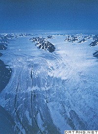
补充资料:冰川地貌
| 冰川地貌 glacial landform 由冰川的侵蚀和堆积作用形成的地表形态。地球陆地表面有11%的面积为现代冰川覆盖,主要分布在极地、中低纬的高山和高原地区。第四纪冰期,欧、亚、北美的大陆冰盖连绵分布,曾波及比今日更为宽广的地域,给地表留下了大量冰川遗迹。 冰川是准塑性体,冰川的运动包含内部的运动和底部的滑动两部分,是进行侵蚀、搬运、堆积并塑造各种冰川地貌的动力。但它不是塑造冰川地貌的唯一动力,是与寒冻、雪蚀、雪崩、流水等各种营力共同作用,才形成了冰川地区的地貌景观。 冰川地貌可分为冰川侵蚀地貌和冰川堆积地貌。冰川侵蚀地貌是冰川冰中含有不等量的碎屑岩块,在运动过程中对谷底、谷坡的岩石进行压碎、磨蚀、拔蚀等作用,形成一系列冰蚀地貌形态,如形成冰川擦痕、磨光面、羊背石、冰斗、角峰、槽谷、峡湾、岩盆等。冰川堆积地貌是冰川运动中或者消退后的冰碛物堆积形成的地貌,如终碛垄、侧碛垄、冰碛丘陵、槽碛、鼓丘、蛇形丘、冰砾阜、冰水外冲平原和冰水阶地等。
冰川地貌组合有一定的分布规律,从冰川中心到外围由侵蚀地貌过渡到堆积地貌。山岳冰川地貌按海拔高度可分为:雪线以上为冰斗、角峰、刃脊分布的冰川冰缘作用带;雪线以下至终碛垄为冰川侵蚀-堆积地貌交错带;最下部为终碛垄、冰川槽谷和冰水平原地带。 |
说明:补充资料仅用于学习参考,请勿用于其它任何用途。
参考词条