1) national coordination system


国家坐标网
2) state coordinate


国家坐标
1.
Three-dimensional separation regression method of transforming GPS coordinate into state coordinate in highway control survey;
公路控制测量中GPS坐标向国家坐标转换的三维分离回归法
3) national coordinate system


国家坐标系
1.
Geometric determination of airborne three line scanner sensors integrated with POS will involve the local tangent plane reference transformation,block adjustment,spatial forword intersection and coordinate conversion between WGS84 coordinate system and national coordinate system,and so on.
集成POS的机载三线阵传感器几何定位将涉及局部切平面坐标系归化、区域网平差、空间前方交会以及WGS84坐标转国家坐标系等方面。
4) state coordinate system


国家坐标系统
5) state plane coordinate system


国家平面坐标系
6) National 2000 coordinate system


国家2000坐标系
补充资料:国家大地坐标原点

国家大地坐标原点
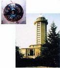
位于西安市北面的泾阳县,距西安市44公里,是中国的地理中心。中华大地原点由中心标志、主体建筑、仪器台等组成,顶部的玻璃制成的观察室可以观察天体的运行,是进行青少年科普教育的好地方。
说明:补充资料仅用于学习参考,请勿用于其它任何用途。