1) star identification map


索星图
3) satellite image retrieval


卫星图像检索
4) star image


星图
1.
A new method of star image high precision extraction besed on local entropy;


基于局部熵的星敏感器星图提取方法
2.
Subdivided locating method of star image for star sensor;


星敏感器中星图图像的星体细分定位方法研究
3.
Track acquisition method of dim target in star images of moving background;


一种运动背景序列星图弱小目标运动轨迹提取算法
5) star graph


星图
1.
This paper first shows that in an n-dimensional star graph Sn where n≥3,for each vertices SV(Sn),|S|=n-1,if Sn-S is disconnected,there exists a vertex v∈V(Sn) such that N(v)=S.
首先证明在n维星图Sn中,当n≥3时如果存在点集SV(Sn),S=n-1使得Sn-S是非连通的,那么存在点v∈V(Sn),N(v)=S。
2.
In this paper,the star total chromatic numbers of general Mycielski′s graphs of star graphs and fan graphs are searched at the different situations,and obtained the star total chromatic numbers of them.
讨论了星图和扇图的广义Mycielski图的星全染色问题,得到了不同情况下它们的星全色数,其中每个点的色集合包含该点及其关联边的颜色。
6) Star map


星图
1.
This paper think the Chinese ancient anstronomer did not use the western projective in the course of drawing star map,on the contrany,they have their own personality methods.
通过对中国古代平面星图画法的研究,认为中国古代的天文学家在绘制星图时并未采用西方投影几何方法。
2.
This paper presents the work of observing stars in the course of reforming calendar in Chong Zhen period at the end of Ming Dynasty,and preliminarily researches into the star catalogues and star maps arising therefrom.
该文介绍明末崇须改历过程中的恒星现测工作,并对由此产生的星表和星图进行初步的研究。
3.
From the above,the thesis made an attempt to prove the importance of China ethnic groups in the development of Star maps.
描述分析已知的中国古代少数民族部分星图基本内容,可知北魏、唐代和辽国的少数民族星图和中原汉民族的星图内容是基本一致的,但吸收了西方的黄道12宫的内容,特别是在辽墓的星图上的黄道12宫图象已趋于中国化。
补充资料:卫星云图
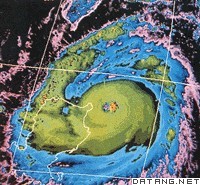
| 卫星云图 satellite cloud imagery 由气象卫星自上而下观测到的地球上的云层覆盖和地表面特征的图像。利用卫星云图可以识别不同的天气系统,确定它们的位置,估计其强度和发展趋势,为天气分析和天气预报提供依据。在海洋、沙漠、高原等缺少气象观测台站的地区,卫星云图所提供的资料,弥补了常规探测资料的不足,对提高预报准确率起了重要作用。
根据卫星上仪器装置的不同,卫星云图可以分成两类:一类是由卫星上电视照相机所拍摄的云图,即电视云图;另一类是由辐射仪对地球大气进行扫描探测得到的云图。在电视云图上,图像的黑白程度表示地表面和各类云对太阳辐射的反射率强弱,白色表示反射率最强,黑色表示反射率最弱。扫描辐射仪探测到的卫星云图又分两种:①用辐射仪测量云和不同性质地表面对太阳辐射可见光的某一波段(如0.52~0.73微米)反射辐射强度时,可以得到一张与电视云图相似的云图。这种云图与电视云图一起,统称作可见光云图。②用辐射仪测量在大气窗区波段(8.5~11微米)来自云顶或地表面放射的红外辐射。这种观测值可以转换成云顶或地表面的辐射温度,用黑白层次表示温度的高低,由此得到一张由云和不同性质地表面的分布图像,称作红外云图。 图像资料的分辨率高低是衡量卫星云图质量高低的重要指标。按照卫星上电视照相机的精度和扫描辐射仪观测的瞬时视场大小,分成低分辨率和高分率辨云图两种。分辨率高,云中细小结构能表示出来。 |
说明:补充资料仅用于学习参考,请勿用于其它任何用途。
参考词条
