1) wind-water erosion region

水蚀风蚀区
2) water-wind erosion crisscross region
水蚀风蚀交错区
1.
Numerical modeling of the soil-water dynamics in water-wind erosion crisscross region on the loess plateau;
黄土高原水蚀风蚀交错区土壤剖面水分动态的数值模拟研究
2.
Evapotranspiration of three types of plants in water-wind erosion crisscross regions in the Loess Plateau
黄土高原水蚀风蚀交错区三种植被蒸散特征
3.
In this study carried out in Liu Daogou watershed in water-wind erosion crisscross region,the undisturbed soil water retention curves of the different(layers) of two soil profiles located at the middle and upper part of a slope were firstly measured by centrifugal method,and then the soil hydraulic parameters such as saturated water content,residual water content,the inverse of the air.
该文在水蚀风蚀交错区六道沟流域分别对居于坡中和坡上两块样地160 cm土层不同深度未扰动土壤的水分特征曲线进行了测定,将V an G enuch tens水分特征曲线模式与M ua lem导水模式相结合,确定了两样地土壤剖面的水力学参数,对水力学参数在剖面的变化进行了分析。
3) wind-water erosion crisscross region
水蚀风蚀交错区
1.
Effect of N fertilization on the mineral nitrogen in soil in wind-water erosion crisscross region on the Loess Plateau
施氮对黄土高原水蚀风蚀交错区土壤矿质氮的影响
2.
By a field positioning observation,we studied soil moisture restoration after rainfalls in the cultivated alfalfa pasture of the wind-water erosion crisscross region of the Loess Plateau.
采用野外定位观测法研究水蚀风蚀交错区苜蓿(Medicago sativa)草地土壤水分在天然降水作用下的恢复过程。
3.
This paper systematically studied the influences of the different vegetation on the soil total nitrogen(TN) and organic matter(OM) in the wind-water erosion crisscross region in China.
通过典型采样与室内分析相结合,系统研究了水蚀风蚀交错区不同典型植被对200 cm土层内土壤全氮、有机质和C/N比值的影响,结果表明:(1)0-40 cm内土壤全氮和有机质含量随深度增加而逐渐下降,40 cm以下基本不随深度变化而变化。
4) wind-water erosion interlaced region
风蚀水蚀过渡区
1.
Extracting land use information of TM image in wind-water erosion interlaced region based on Texture
基于纹理的风蚀水蚀过渡区TM影像土地利用信息提取
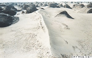
补充资料:风蚀地貌
| 风蚀地貌 wind-erosion landform 风力吹蚀、磨蚀地表物质所形成的地表形态。风蚀地貌的主要类型有:①风蚀石窝。陡峭的迎风岩壁上风蚀形成的圆形或不规则椭圆形的小洞穴和凹坑。大的石窝称为风蚀壁龛。②风蚀蘑菇。孤立突起的岩石经风蚀作用而成的蘑菇状岩体,又称石蘑菇、风蘑菇。③雅丹地形。河湖相土状堆积物地区发育的风蚀土墩和风蚀凹地相间的地貌形态。雅丹是中国维吾尔语,意为陡峭的土丘,因中国新疆孔雀河下游雅丹地区发育最为典型而命名。其发育过程是:挟沙气流磨蚀地面,地面出现风蚀沟槽。磨蚀作用进一步发展,沟槽扩展为风蚀洼地;洼地之间的地面相对高起,成为风蚀土墩。④风蚀城堡。水平岩层经风蚀形成的城堡式山丘,又称为风城。多见于岩性软硬不一(如砂岩与泥岩互层)的地层,中国新疆东部十三间房一带和三堡、哈密一线以南的第三纪地层形成了许多风城。⑤风蚀垅岗。软硬互层的岩层中经风蚀形成的垅岗状细长形态。一般发育在泥岩、粉砂岩和砂岩地区。⑥风蚀谷。风蚀加宽加深冲沟所成的谷地。谷无一定的形状。风蚀谷不断扩大,原始地不断缩小,最后仅残留下一些孤立的小丘,即风蚀残丘。⑦风蚀洼地。松散物质组成的地面经风蚀所形成椭圆形的成排分布的洼地。较深的风蚀洼地如以后有地下水溢出或存储雨水即可成为干燥区的湖泊,如中国呼伦贝尔沙地中的乌兰湖等。
|
说明:补充资料仅用于学习参考,请勿用于其它任何用途。
参考词条