1) Baotaping


宝塔坪
1.
Brief Report on Excavation of Baotaping Site,Fengjie in 2003;


奉节宝塔坪遗址2003年发掘简报
2) Huangshaping Baoshan ore field


坪宝矿田
1.
Ag deposit of Huangshaping Baoshan ore field is an accopanying deposit,Its metallogenic matrices are the granodiorite porphyry and quart porphyry.
坪宝矿田银矿床为伴、共生矿床,花岗闪长斑岩、石英斑岩是其成矿母岩,但银含量远离岩体有增高的趋势;银矿床与铅锌、锰矿床共生时银含量高,与铜钨钼矿床共生时银含量较低;银矿床还存在次生富集的现象。
3) pagoda
[英][pə'ɡəʊdə] [美][pə'godə]


宝塔
1.
ANSYS analysis of structure transform node of Hongzhou pagoda;


洪洲宝塔结构转换节点的ANSYS分析
4) Kalpintag


柯坪塔格
1.
The Kalpintag nappe is located at the southwestern foot of the Tianshan Mountains,consisting of several rows of NE-to EW-trending fold-reverse fault zones.
柯坪塔格推覆体位于天山西南麓,由多排NEE—EW向的褶皱-逆断裂带组成。
2.
Based on a lot of outcrop geological surveys, we discussed the thrust fault belt in the front of the east section of Kalpintag in Kalpin area and found many evidences, including the fault incising the surface of diluvium and fluvial channel sediments and terraces, and also the fracture and subsection character of the faults.
柯坪塔格前缘断裂东段是柯坪推覆构造系前缘的一条活动断裂,野外调查获得了其晚第四纪错断洪积扇、冲沟阶地面的证据,实测了变形地貌面上的断层陡坎,分析了断层的形变量,通过采样测年估算了断层的缩短速率。
3.
This paper tries to discuss paleoearthuakes along the east section of the range front fault of Kalpintag during late Quaternary by doing field investigation along the fault, measuring geomorphic deformation and excavating trenches in some important sites where young alluvial fans were displaced obviously.
文中试图通过对柯坪推覆构造区的影像解译和野外观察、断错地貌的实测和探槽开挖,探讨柯坪塔格山前断裂东段晚第四纪以来的古地震活动。
5) Taping landslide


塔坪滑坡
6) Baota district


宝塔区
1.
The Study on Geographical Hazard Evaluation of Baota District in Yan an City;


延安宝塔区地质灾害危险性评价研究
2.
Based on field investigation and analyzing the material of Baota district, the theories of eco environmental planning is applied to evaluate the eco environmental features of this area, which is divided into five grades.
根据实地考察和资料分析 ,应用区域生态环境规划理论对宝塔区生态环境状况进行了评价 ,划分出不同的生态环境质量等级。
3.
In order to dynamically monitor soil erosion and determine the relationship between landuse and soil erosion in Baota District of Yan an City,an analysis was performed using the data from TM images in the two periods of 1997 and 2004.
以TM影像为数据源,动态监测了延安市宝塔区1997,2004年的土地利用、土壤侵蚀的时空变化,并对该变化进行了分析。
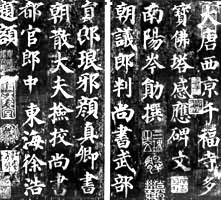
补充资料:《多宝塔感应碑》册(宋拓本)
《多宝塔感应碑》册(宋拓本)
中国唐代书法家颜真卿所书碑刻的宋拓本。剪条装,1册47页,每页5行,行10字。纵26.7厘米,横15.8厘米。正书,结字平稳谨严,布局紧凑,笔法方折丰劲,是颜真卿早期楷书的代表作品。
此拓本纸墨精古,
 铩宛然,文中“
 井见泥”的“
 ”字笔画完好,有王澍、沈凤、李宗瀚题跋,张彦生《善本碑帖录》著录。原为沈凤、李宗瀚先后收藏,后归故宫博物院。
这是颜真卿 44 岁时的作品,碑文由岑勋撰写,史华刊刻,徐浩题额“大唐多宝塔感应碑”。天宝十一年(752) 立于兴平千福寺(今陕西兴平县境内)。今存陕西省西安碑林。
[碑文局部]

施安昌
说明:补充资料仅用于学习参考,请勿用于其它任何用途。
参考词条