1) collapse surface


崩塌面
1.
The potential instability line is established on the p -q plane, which is on the “collapse surface”.
文中提出的“不稳定线”与“崩塌面”相一致,表明了它在海底稳定性分析中有着广泛的实践意义。
2) slope dilapidation


坡面崩塌
3) collapse
[英][kə'læps] [美][kə'læps]


崩塌
1.
Formation mechanism and movement characteristic of a high altitude collapse on the No.108 National Highway in west Sichuan Province;
川西108国道高位崩塌成因与运动特征
2.
The causes of collapse along Dazhun railway line and preventive measures;


大准铁路沿线崩塌形成条件及防治措施研究
3.
Geological Hazards of Huangluquan Collapse and Its Prevention Countermeasures in Zhangqiu City;
章丘市黄露泉崩塌地质灾害及防治对策
4) landslip
[英]['lændslɪp] [美]['lænd'slɪp]


崩塌
1.
Based on past research,the paper analyzed systematically and comprehensively the natural and artificial factors leading to landslip geo-hazard in Zhaoyuan gold field,Shandong.
在总结前人研究成果的基础上,全面系统地分析了诱发招远市金矿区崩塌的自然和人为因数,然后运用遥感技术对金矿区遥感图像进行处理,提取诱发崩塌的条件因子,聘请有经验的专家对各项诱发因子进行诊断分析,以此作为判断条件,在G IS技术的支持下对诱发崩塌的条件因子进行空间分析,预测出招远金矿区发生崩塌的危害程度,为防治崩塌提供科学依据。
2.
Based on the understanding of the mountain disaster in the three gorge reservoir, this article gave a detailed analysis of the landslip, landslide debris flow and the loss of the soil and water, which was caused by mountain disaster.
长江三峡库区是山地灾害多发区 ,本文阐述了库区崩塌 ,滑坡 ,泥石流等山地灾害的基本特性以及由此而产生的水土流失 。
3.
Through field investigation and analysis,combining with historical earthquake documents,the causes of landform,rift valley and landslip relic of Xionger mountain is studied.
通过实地考察和分析,结合历史地震记载资料,对熊耳山地貌、裂谷以及崩塌遗迹的形成原因进行了初步探讨。
5) landslide
[英]['lændslaɪd] [美]['lænd'slaɪd]


崩塌
1.
Application of the remote sensing technique to monitor landslides of Hualien debris disaster watershed areas
应用遥测技术探讨台湾花莲地区土砂灾害集水区崩塌地的变迁
2.
It s concluded that the cause of rocks landslide is integration of both inside and outside factors,such as the rocks physical and mechanical characteristics,rainfall,weathering,human activities,etc.
阐述了危岩体特征,岩体的变形机理,岩石物理力学特征以及雨水、风化、人工活动等内外营力的综合作用是崩塌产生的原因,并对危岩体稳定性分析与评价,在此基础上提出"ISNS"柔性防护措施。
3.
The study was implemented by spatial analysis with GIS from landslide sites versus physiographic features,hydrologic features,land-use,and aerial photo interpretation to trace the sediment sources and the reasons attributing to the slopeland hazards.
针对2次台风对于石门水库集水区崩塌地分布与地文、水文及人为开发等因素之间的关系,透过地理信息系统分析,探讨土砂的来源分布与致灾原因。
6) Avalanche
[英]['ævəlɑ:nʃ] [美]['ævə'læntʃ]


崩塌
1.
The study on properties of the avalanches in granular assemblies;


颗粒聚集体的崩塌性质研究
2.
Preliminary study on classification for highway avalanche hazards


公路崩塌灾害等级划分初步研究
3.
Mountain disasters in our country maintly consist of avalanche slide, landslide, mud rock flow, (ALM), which have been lasting threats to people s lives and socio economic stability and have greatly damaged the natural environment and resources.
我国山地灾害主要以崩塌、滑坡及泥石流为主 (称崩滑流灾害 )。
补充资料:崩塌
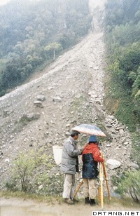
| 崩塌 avalanche 陡峻山坡上岩块、土体在重力作用下 ,发生突然的急剧的倾落运动。多发生在大于60°~70°的斜坡上。崩塌的物质,称为崩塌体。崩塌体为土质者,称为土崩;崩塌体为岩质者,称为岩崩;大规模的岩崩,称为山崩。崩塌可以发生在任何地带,山崩限于高山峡谷区内。崩塌体与坡体的分离界面称为崩塌面,崩塌面往往就是倾角很大的界面,如节理、片理、劈理、层面、破碎带等。崩塌体的运动方式为倾倒、崩落。崩塌体碎块在运动过程中滚动或跳跃,最后在坡脚处形成堆积地貌——崩塌倒石锥。崩塌倒石锥结构松散、杂乱、无层理、多孔隙;由于崩塌所产生的气浪作用,使细小颗粒的运动距离更远一些,因而在水平方向上有一定的分选性。
|
说明:补充资料仅用于学习参考,请勿用于其它任何用途。
参考词条
