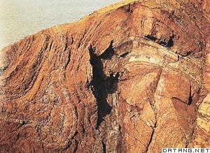
1) tectonic-landform evolution


构造-地貌演化
2) landform evolution


地貌演化
1.
Landform evolution in the south was earlier.


Strahler)提出的面积-高程分析法为基础,在MapGIS单一系统下研究了湟水流域的地貌演化过程。
2.
The difference between landform evolution of Xingzihe basin and Davis s model is that because there were three times endogenic uplift action on Qut.
杏子河地貌演化与戴维斯(Davis)模型的不同点是地貌未达准平原,就有内营力抬升作用,结果使地貌长期处于非平衡态。
3) geomorphological evolution


地貌演化
1.
This special geomorphological evolution result will greatly influence the stability of submarine pipeline and bottom-sited platform; it should be pay more attention in designing and constructing of submarine structures.
三角洲特殊的地貌演化结果对海底管线、座底式平台稳定造成很大危害,在构筑物设计和施工过程中应予以重视。
2.
Sediment dynamic and environment research in Minjiang estuary was summarized in this paper from four aspects:Minjiang estuary delta geomorphological evolution,sediment dynamic and sediment transport,division of sedimentary environments,as well as salt and fresh water mixing.
本文比较系统的综述了闽江河口沉积动力环境方面已做过的研究工作,根据取得的成果从闽江河口三角洲的地貌演化、沉积动力和泥沙运移、沉积环境分区和盐、淡水混合四个方面进行了总结,并对当前研究工作所存在的问题进行了分析,提出了今后的重点研究方向。
4) landforms evolution


地貌演化
1.
Water and soil loss is an important landforms evolution course.


水土流失其实是一种主要的侵蚀地貌演化过程。
5) geomorphic evolution


地貌演化
1.
The geomorphic evolution was discussed based on the sedimentary features and the correlation of the Late Cenozoic stratums.
在对研究区进行了地貌分区的基础上 ,探讨了研究区的地貌演化特征 ,并进行了研究区的晚第三纪地层对比。
2.
According to the record of eolian & lake deposit and their chronology date in the northern Ulan Buh Desert in the Holocene, it is stated that Ulan Buh Desert s process of geomorphic evolution in the Holocene can be divided into 4 stages: (1) Lake Geomorphy stage in Q_3~3-Q_4~1.
根据对乌兰布和沙漠北部地区全新世风沙和湖泊沉积记录及其沉积时代进行分析,认为全新世以来,乌兰布和沙漠北部地区地貌演化经历了4个主要的发育时期:Q33~Q41湖泊地貌发育时期,Q41风沙地貌发育时期,Q42湖(河)(屠申泽)地貌发育时期和Q43风沙地貌发育时期。
补充资料:构造地貌
| 构造地貌 structural landform 由地质构造作用形成的地貌。包括地质时期的构造和新第三纪以来形成的新构造。构造地貌的主要类型有:板块构造地貌、断层构造地貌、褶曲构造地貌、火山构造地貌、熔岩构造地貌和岩石构造地貌。地质时期形成的各种构造受外力侵蚀作用后形成的地貌。如背斜山、背斜谷;向斜山、向斜谷;断层崖、断层线崖等。由新构造运动形成的褶曲、断层等遗迹,称为新构造。新构造运动可以分为垂直运动和水平运动。地壳垂直运动形成的地貌,如上升的山地、丘陵、台地;下降的平原、盆地;间歇上升的阶地等。大范围的地壳水平运动使地壳产生挤压或拉张,可以形成大规模的大陆褶皱山系高原、大陆裂谷、断陷盆地;大陆边缘的岛弧、海沟、大陆波;洋底中脊、火山等地貌类型。
|
说明:补充资料仅用于学习参考,请勿用于其它任何用途。
参考词条
