2) digital land price model


数字地价模型
1.
Based on the land grading and evaluation,establishment of digital land price model,collocation of monitoring points by overlay analysis of TIN node and lot Layer,land price update of monitoring points based on market data approach,update of land price TIN are presented,and a method and technical route for collocating the monitoring points of urban land price based on digital land pr.
从数字地价模型的建立、格网数字地价模型向TIN转化、TIN节点与宗地图层叠加拟合完成地价监测点的定位配置、结合市场比较法的监测点地价更新、TIN数字地价模型更新等几个方面详细阐述了数字地价模型运用于地价监测点配置的具体方法。
2.
Digital land price model is the spatial three-dimensional expression of urban land price level.
数字地价模型是对城镇地价高低的空间立体表达方式。
3) mathematical model for evaluating forest land


林地价格模型
5) land assessment model


土地评价模型
1.
The advantage, methodology and procedure of the small watershed land assessment model applied to land assessment of TAOYUAN watershed are discussed and described systematically by taking agricultural suitability and forest suitability of land as objects of land assessment.
通过以江西省赣县桃源河小流域宜农、宜林、不宜地为评价目标,系统地论述了小流域土地评价模型在赣县桃源河小流域土地评价中应用的作用、过程和方法步骤,并对模型所计算的结果进行了详细分
6) land price model


地价测算模型
补充资料:AutoCad 教你绘制三爪卡盘模型,借用四视图来建模型
小弟写教程纯粹表达的是建模思路,供初学者参考.任何物体的建摸都需要思路,只有思路多,模型也就水到渠成.ok废话就不说了.建议使用1024X768分辨率
开始
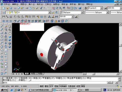
先看下最终效果

第一步,如图所示将窗口分为四个视图

第二步,依次选择每个窗口,在分别输入各自己的视图

第三步,建立ucs重新建立世界坐标体系,捕捉三点来确定各自的ucs如图

第四步,初步大致建立基本模型.可以在主视图建立两个不同的圆,在用ext拉升,在用差集运算.如图:

第五步:关键一步,在此的我思路是.先画出卡爪的基本投影,在把他进行面域,在进行拉升高度分别是10,20,30曾t形状.如图:

第六步:画出螺栓的初步形状.如图

第七步:利用ext拉升圆,在拉升内六边形.注意拉升六边行时方向与拉升圆的方向是相反的.
之后在利用差集运算


第八步:将所得内螺栓模型分别复制到卡爪上,在利用三个视图调到与卡爪的中心对称.效果如图红色的是螺栓,最后是差集

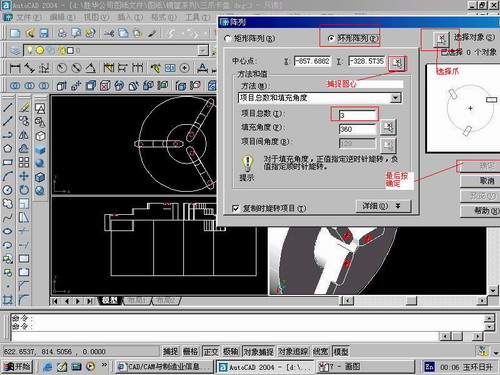
第九步:阵列

第10步.模型就完成了

来一张利用矢量处理的图片

说明:补充资料仅用于学习参考,请勿用于其它任何用途。
参考词条