1) stratum model


地层模型
1.
Based on the production and data of regional geological survey in Shenmu area of north Shaanxi with 1∶50 000, this paper systemically analyzes the stratigraphic order characteristics of coal-bearing strata in Mesozoic, and the sedimentary patterns in the basin, and the rock-stratum model in this area is established at the first step.
以陕北神木地区1∶5万区域地质调查成果资料为基础,运用层序地层学的理论和方法,系统分析与研究了该区中生代含煤岩系的层序地层特征、盆地充填样式,初步建立了该地区区域岩石地层模型。
2) earth model


地层模型
1.
A method is developed for the synthesis of randomly layered earth models on a computer.


介绍了一种利用计算机生成随机数字地层模型的方法。
3) stratigraphic model


地层模型
1.
The achievements made can guide the interpreter to design a stratigraphic model.


论述了用数字方法设计出地层弹性波速度模型的原理和方法,阐述了地震射线追踪法的算法并用其对数字模型的反射、折射波时距曲线做了计算,通过实例分析了复杂速度结构与地震剖面的对应关系,可指导解释人员根据实际地质情况任意设计地层模型进行计算,很快得出结果。
4) seismic stratigraphic model


地震地层模型
5) reservoir geological model


储层地质模型
1.
A high-precision reservoir geological model was established,and a general modeling flowchart was given.
建立了反映实际储层微相分布的高精度储层地质模型,给出了具体建模流程。
2.
As the analysis is the key content for a reservoir geological model, on the basis of the reservoir geological model of the deltaic system in the faulted basin of eastern China, the authors analysize the features of its structural types and true .
由于构形要素分析是建立储层地质模型的关键内容,因此,笔者在所建立的储层地质模型上,分析了其结构类型特点及建立储层地质模型的真实内涵。
6) formation model of depth domain


深度域地层模型
1.
Application of formation model of depth domain in reservoir prediction;


深度域地层模型在储层预测中的应用
补充资料:AutoCad 教你绘制三爪卡盘模型,借用四视图来建模型
小弟写教程纯粹表达的是建模思路,供初学者参考.任何物体的建摸都需要思路,只有思路多,模型也就水到渠成.ok废话就不说了.建议使用1024X768分辨率
开始
先看下最终效果

第一步,如图所示将窗口分为四个视图

第二步,依次选择每个窗口,在分别输入各自己的视图

第三步,建立ucs重新建立世界坐标体系,捕捉三点来确定各自的ucs如图

第四步,初步大致建立基本模型.可以在主视图建立两个不同的圆,在用ext拉升,在用差集运算.如图:

第五步:关键一步,在此的我思路是.先画出卡爪的基本投影,在把他进行面域,在进行拉升高度分别是10,20,30曾t形状.如图:

第六步:画出螺栓的初步形状.如图

第七步:利用ext拉升圆,在拉升内六边形.注意拉升六边行时方向与拉升圆的方向是相反的.
之后在利用差集运算


第八步:将所得内螺栓模型分别复制到卡爪上,在利用三个视图调到与卡爪的中心对称.效果如图红色的是螺栓,最后是差集

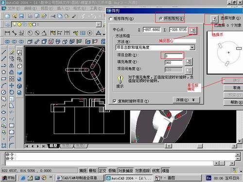
第九步:阵列

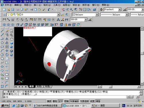
第10步.模型就完成了

来一张利用矢量处理的图片

说明:补充资料仅用于学习参考,请勿用于其它任何用途。
参考词条