1) Shiquan River

狮泉河
1.
The climate changing trend and prediction in Northwest Tibet represented by the Shiquan River meteorological station;
西藏西北高原气候变化趋势及预测——以狮泉河站为例
2.
The Shiquan River ophiolitic mélange zone in Xizang: The delineation and significance of a new archipelagic are-basin system;
西藏狮泉河蛇绿混杂岩带——一个新的多岛弧盆系统的厘定及意义
3.
Aquatic Biotic Resources and Biology of S.stoliczkai Stoliczkai Steindachner in Shiquan River;
狮泉河水生生物资源和高原裸裂尻鱼的生物学研究
2) Shiquanhe basin
狮泉河盆地
1.
Cause of wind-blown sand disaster in Shiquanhe Basin and its control;
狮泉河盆地风沙灾害成因及其防治
2.
The paper, according to its natural, economic conditions and features of wind-sand, works out a set of comprehensive plan for controlling wind-sand in Shiquanhe basin composed of mechanical, biological and assistant measures.
根据狮泉河盆地自然、社会经济条件和风沙灾害特点,制定了由机械措施、生物措施和辅助措施组成的综合整治方案。
3) The Shiquanhe Valley
狮泉河谷地
4) Shiquanhe wide valley
狮泉河宽谷
1.
The desertification of the Shiquanhe wide valley occurs on the background of environmental degradation of the Qinghai─Xizang plateau and is strengthened with manmade irrational use of natural resources.
狮泉河宽谷区的荒漠化过程以整个青藏高原的环境演变为背景,受人为的资源利用不合理而强化。
5) Shiquanhe Hydropower Station
狮泉河水电站
1.
Experiment on relationship between maximum dry density and grain size composition for mixing material of earth-rock fill dam with clay core of Shiquanhe Hydropower Station;
狮泉河水电站粘土心墙土石坝掺合料最大干密度及颗分关系试验
2.
Quality Control of Installation and Welding of the Spiral Case (Stay Ring) of Shiquanhe Hydropower Station;
狮泉河水电站蜗壳(座环)安装焊接质量控制
3.
Optimization Adjustment on the Unit Number and Capacity of Shiquanhe Hydropower Station;
狮泉河水电站机组台数及单机容量优化调整
6) Yecheng-Shiquanhe area
叶城-狮泉河地区
补充资料:狮泉河
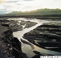
| 狮泉河 在中国西藏自治区西部。 藏语称“森格藏布”,意为“狮口河”。源出冈底斯山主峰冈仁波齐峰北部的森格喀巴林附近,源头海拔5164米,西流在扎西岗附近与噶尔藏布汇合后,向西北流出国境后,改称印度河。在中国境内河长430千米,流域面积2.75万平方千米。地处西藏干燥地区,流域年平均径流深仅25毫米,水系不发育,主要支流有生拉藏布、公前河、赤左藏布、婆肉共河、朗久河、噶尔藏布等。河流除接受雨水和冰雪融水补给外,地下水补给量占比例很大,约占年径流量的67%。径流的年内分配和年际变化比较稳定。河水温度低,年平均水温3℃,河流结冰期长,一般于10月底出现岸冰,至翌年4月的中、下旬才完全消融,其中12月至翌年2月河流还出现封冻现象。
|
说明:补充资料仅用于学习参考,请勿用于其它任何用途。
参考词条