1) geomorphologic characteristics


地貌特点
1.
The geomorphologic characteristics,causes as well as the development and utilization value of the surfaces are analyzed.
本文分析了该区域残余古地形面的地貌特点、成因及其利用价值。
2) geologic and geographic conditions


地质地貌特点
3) geomorphological characteristics


地貌特征
1.
<Abstrcat>The geomorphological characteristics,palaeoenvironment and paleoculture of the Chengdu plain are studied,also the relationships between them, which is helpful to understand the process of development of the paleoculture more deeply and realize that the paleoculture has close relationship with the geomorphological characteristics and palaeoenvironment.
对成都平原的地貌特征、古环境、古文化进行了研究,初步探讨了成都平原地貌特征、古环境与古文化之间的关系,从而加深了对成都平原古文化发生、发展的过程的理解,也认识到古文化与地貌特征及古环境息息相关。
4) topographic features


地貌特征
1.
In this paper,we take Xiaoshan-Qiuchuan Faults as an example,the detailed rupture character is analyzed from a viewpoint of geological and topographic features,and .
本文以萧山—球川断裂为例,在地质地貌特征上进行了详细的分析,揭示其几何学和运动学特征。
5) landform feature


地貌特征
1.
An implementation of mining subsidence DEM considering landform feature;


顾及地貌特征的矿区地表塌陷DEM的生成方法
2.
For many years, the geomorphology research has devoted to theresearch on landform features of the large region at small scale, and theresearch on landform features and process of the small region at big scaleprogress slowly.
多年来,地貌学研究绝大多数致力于大区域小比例尺的地貌特征的研究,对于小区域大比例尺的地貌特征与过程的研究进展缓慢。
6) geomorphical characteristic


地貌特征
1.
Through the study of geomorphical characteristics in the bordering coastal area between Shanghai and Jiangsu province, the paper provides technical results for deciding sea-area borderline of Shanghai and Jiangsu province.
海域勘界工作是加强海域综合管理,有效实施海域使用,发展海洋经济和维护沿海安定团结的一项重要措施,该论文通过研究上海市与江苏省海域勘界地区的地形地貌特征和岸滩演变,为勘定沪苏省际间海域界线提供了技术依据。
补充资料:冰川地貌
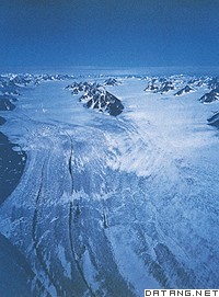
| 冰川地貌 glacial landform 由冰川的侵蚀和堆积作用形成的地表形态。地球陆地表面有11%的面积为现代冰川覆盖,主要分布在极地、中低纬的高山和高原地区。第四纪冰期,欧、亚、北美的大陆冰盖连绵分布,曾波及比今日更为宽广的地域,给地表留下了大量冰川遗迹。 冰川是准塑性体,冰川的运动包含内部的运动和底部的滑动两部分,是进行侵蚀、搬运、堆积并塑造各种冰川地貌的动力。但它不是塑造冰川地貌的唯一动力,是与寒冻、雪蚀、雪崩、流水等各种营力共同作用,才形成了冰川地区的地貌景观。 冰川地貌可分为冰川侵蚀地貌和冰川堆积地貌。冰川侵蚀地貌是冰川冰中含有不等量的碎屑岩块,在运动过程中对谷底、谷坡的岩石进行压碎、磨蚀、拔蚀等作用,形成一系列冰蚀地貌形态,如形成冰川擦痕、磨光面、羊背石、冰斗、角峰、槽谷、峡湾、岩盆等。冰川堆积地貌是冰川运动中或者消退后的冰碛物堆积形成的地貌,如终碛垄、侧碛垄、冰碛丘陵、槽碛、鼓丘、蛇形丘、冰砾阜、冰水外冲平原和冰水阶地等。
冰川地貌组合有一定的分布规律,从冰川中心到外围由侵蚀地貌过渡到堆积地貌。山岳冰川地貌按海拔高度可分为:雪线以上为冰斗、角峰、刃脊分布的冰川冰缘作用带;雪线以下至终碛垄为冰川侵蚀-堆积地貌交错带;最下部为终碛垄、冰川槽谷和冰水平原地带。 |
说明:补充资料仅用于学习参考,请勿用于其它任何用途。
参考词条
