1) Chaiwopu basin


柴窝堡盆地
1.
Modelling of regional groundwater flow of the Chaiwopu Basin and the river valley in the Urumqi River catchment
乌鲁木齐河流域柴窝堡盆地与河谷区地下水流模拟
2.
The concept of the grain-size genetic unit and its research methods were put forward,and applied to establish high-resolution isochronous sequence framework of Loucaogou Formation of Middle Permian in Chaiwopu basin.
在Goodwin和Anderson于1985提出的PAC假说基础上,针对目前基准面旋回级别划分较为混乱的状况,将基准面旋回赋予了自旋回和异旋回的涵义,探索性地提出了粒度成因单元的概念和研究方法,并将其应用到柴窝堡盆地中二叠统芦草沟组高分辨率层序地层的研究中,建立了该区中二叠统芦草沟组高分辨率层序地层格架,划分出了2个长期基准面旋回6个中期粒度成因单元以及和体系域相似的5个层段。
3.
Chaiwopu basin had more abundant oil-gas resource and good petroleum preservation conditions, but only Well Chaican-1-Cl, which drilled in 1989, had commercial oil/gas flows now, Loucaogou Formation of Middle Permian was one of its mainly production stratas.
柴窝堡盆地具有较丰富的油气资源和良好的油气成藏地质条件,但目前只有1989年完钻的柴参1井(地)具有工业油气流,其中中二叠统的芦草沟组是其主要产油气层位。
4) Chaiwopu Area


柴窝堡地区
1.
In accordance with well testing data,the paper also formulates identification standards of oil and gas layers and evaluates reservoir physical characteristics and gas-bearing characteristics in Chaiwopu Area.
在研究了以岩心、录井及实验室分析资料的基础上,采用了岩心刻度测井分析技术,建立了岩性判别标准和储层物性及含油气性测井解释模型,结合测试成果资料,制定了油气层判别标准,并对柴窝堡地区储层物性及含油气性进行了评价。
5) Chaiwopu


柴窝堡
1.
Petroleum Characteristics and Prospecting Target in Chaiwopu Seg,Junggar Basin;


柴窝堡凹陷石油地质特征及勘探方向
2.
Environmental Problems Caused by Excessive Exploitation of Groundwater at Chaiwopu Source in Xinjiang;
新疆柴窝堡水源地地下水超采引发的环境问题
3.
Chaiwopu Depression, locates between Bogeda mountain and Yilinhebilgen mountain, is a intermountain basin developed on the basis of the early Hercynian folded rocks.
柴窝堡凹陷位于博格达山和伊连哈比尔尕山之间,是在海西早期褶皱岩系基础上发育起来的山间盆地。
6) Chai Wo-pu Lake


柴窝堡湖
1.
Assessment on Water Eutrophication Level of Chai Wo-pu Lake;


柴窝堡湖富营养化水平评价
补充资料:柴窝堡

柴窝堡
※ 亚洲第一风力发电厂 ※
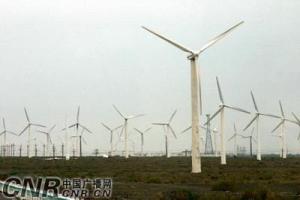
柴窝堡—达坂城谷地年平均风速6. 2米/ 秒,有效风能2000-3000千瓦·小时/ 平方米·年,是全国著名风口之一,最大风速为34米/ 秒,瞬间最大风速超过40米/ 秒。柴窝堡风力发电厂是亚洲最大的风力发电厂,目前装机容量为6. 65万千瓦。数千座风车整齐地排列在戈壁上,颇为壮观。
说明:补充资料仅用于学习参考,请勿用于其它任何用途。