1) Models computed


模型解算
2) solution model


解算模型
1.
Through analyzing the existent methods for solving the intersection point coordinate of straight line and highway curve,combined with the general mathematical model for highway curve,a general solution model for the intersection point coordinate is given.
通过对现有的直线与线路曲线交点坐标解算方法的分析,结合线路曲线的统一数学模型,给出了直线与线路曲线交点坐标的统一解算模型。
2.
The calculation results show that the solution model and the precision assessment have higher applicabilit.
研究建立了大型雷电探测网雷电定位解算模型及图形因素分析,结果表明该模型对大型雷电定位计算及精度评价具有较高的适用性,并可作为制定相关标准的理论依据。
3) analytical model and algorithm


解析模型和算法
4) direct georeferencing model


直接解算模型
1.
It introduces direct georeferencing model and givesthe connection between imagery coordinatesand objective coor-dinates of the ground points according the colinearity equations, so the problem can be solved by indi-rect adjustment.
最后对直接解算模型进行了精度分析。
6) track calculating formula


跟踪解算模型
1.
Because the unknown of gun s track calculating formula,the moving positions of track ring is recorded in various gun s angle speed and different shooting distances,the moving rule of track ring is found by the program with the using of the least square beeline fit under linearity parameter .
在某型高炮跟踪解算模型不可知的情况下,实测记录跟踪圆环在不同的身管角速度和击发距离档下的运动数据,利用线性参数模型最小二乘辨识的原理编制程序进行直线拟合,找出它的运动规律,形成近似的跟踪解算模型。
补充资料:AutoCad 教你绘制三爪卡盘模型,借用四视图来建模型
小弟写教程纯粹表达的是建模思路,供初学者参考.任何物体的建摸都需要思路,只有思路多,模型也就水到渠成.ok废话就不说了.建议使用1024X768分辨率
开始
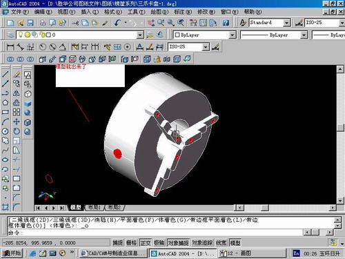
先看下最终效果

第一步,如图所示将窗口分为四个视图

第二步,依次选择每个窗口,在分别输入各自己的视图

第三步,建立ucs重新建立世界坐标体系,捕捉三点来确定各自的ucs如图

第四步,初步大致建立基本模型.可以在主视图建立两个不同的圆,在用ext拉升,在用差集运算.如图:

第五步:关键一步,在此的我思路是.先画出卡爪的基本投影,在把他进行面域,在进行拉升高度分别是10,20,30曾t形状.如图:

第六步:画出螺栓的初步形状.如图

第七步:利用ext拉升圆,在拉升内六边形.注意拉升六边行时方向与拉升圆的方向是相反的.
之后在利用差集运算


第八步:将所得内螺栓模型分别复制到卡爪上,在利用三个视图调到与卡爪的中心对称.效果如图红色的是螺栓,最后是差集

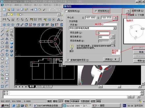
第九步:阵列

第10步.模型就完成了

来一张利用矢量处理的图片

说明:补充资料仅用于学习参考,请勿用于其它任何用途。
参考词条