1) remote sensing monitoring model


遥感监测模型
1.
Then the spectral monitoring model and the satellite remote sensing monitoring model of winter wheat biomass are established,providing theory basis for dynamic monitoring on winter wheat growth.
本文利用1992-1994年乌兰乌苏农业气象试验站观测农学资料、光谱资料以及同步接收的NOAA/AVHRR资料,计算了冬小麦生物量与比值植物指数(RVI)和归一化差值植被指数(NDVI)的相关系数,并建立了冬小麦生物量的光谱监测模型和气象卫星遥感监测模型,为冬小麦长势的动态监测提供了理论依据。
2) remote sensing


遥感监测
1.
Monitoring the change of the Yellow River Estuary with remote sensing andanalysis of flow and sediment condition in the last ten years;
黄河口近十年变化遥感监测及水沙条件分析
2.
Method for land resources monitoring by remote sensing data on large-scale;


土地资源遥感监测产业化应用方法探讨
3.
Monitoring Phyllostachys pubescens stands expansion in National Nature Reserve of Mount Tianmu by remote sensing;
天目山国家级自然保护区毛竹林扩张遥感监测
3) remote sensing monitoring


遥感监测
1.
Method for remote sensing monitoring of desertification based on MODIS and NOAA/AVHRR data;
基于MODIS和NOAA/AVHRR的荒漠化遥感监测方法
2.
Remote Sensing Monitoring of Lake Qinghai Based on EOS/MODIS Data;


基于 EOS/MODIS 数据的青海湖遥感监测
3.
Realization of sustainable management of agricultural water supply in Beijing with ET technique of remote sensing monitoring;
应用遥感监测ET技术实现北京市农业用水的可持续管理
4) monitoring by remote sensing


遥感监测
1.
From the regionality viewpoint,this paper discussed the methods of built-up landcover change monitoring by remote sensing in large-scale regions.
从珠江三角洲区域总体出发 ,探讨大范围城镇建筑覆盖变化的遥感监测方法。
5) remote sensing monitor


遥感监测
1.
Study of remote sensing monitor and driving forces of the construction land of urban——A case sStudy in Beibei district of Chongqing
城市建设用地遥感监测及动力机制研究——以重庆市北碚区为例
2.
Based on the project of resource and environment remote sensing monitor surrounding Beijing, some key technology such as data preprocessing, information abstraction, dynamic monitor analysis and data quality control have been discussed in this study.
文章以环北京地区资源与生态环境遥感监测项目为依托,讨论了资源与生态环境遥感监测业务化工作中数据预处理、信息提取、动态监测分析、外业调查、数据质量控制等技术关键环节,并重点阐述了资源与生态环境遥感监测工作中亟需解决的若干问题及思路,以期为今后全国范围内资源与生态环境遥感监测提供指导和借鉴。
6) monitoring
[英]['mɔnitə] [美]['mɑnətɚ]


遥感监测
1.
Based on the information from monitoring Poyang Lake with satellite remote sensing in recent years, the water flood model of Poyang Lake and its neighbourhood regoins is established.
根据近年来卫星遥感监测实况资料建立了鄱阳湖主体及其附近区域水体淹没模型。
2.
Firstly, discussed the developmental course of the soil and water monitoring, and divided it into six phases by sequence; and then, summarized the applied status of each method in Karst region soil and water loss monitoring; Fi.
喀斯特地区生态环境的脆弱性,以及遥感和地理信息系统技术的不断发展,决定了在该地区进行水土流失遥感监测的重要性和紧迫性。
补充资料:AutoCad 教你绘制三爪卡盘模型,借用四视图来建模型
小弟写教程纯粹表达的是建模思路,供初学者参考.任何物体的建摸都需要思路,只有思路多,模型也就水到渠成.ok废话就不说了.建议使用1024X768分辨率
开始
先看下最终效果

第一步,如图所示将窗口分为四个视图

第二步,依次选择每个窗口,在分别输入各自己的视图

第三步,建立ucs重新建立世界坐标体系,捕捉三点来确定各自的ucs如图

第四步,初步大致建立基本模型.可以在主视图建立两个不同的圆,在用ext拉升,在用差集运算.如图:

第五步:关键一步,在此的我思路是.先画出卡爪的基本投影,在把他进行面域,在进行拉升高度分别是10,20,30曾t形状.如图:

第六步:画出螺栓的初步形状.如图

第七步:利用ext拉升圆,在拉升内六边形.注意拉升六边行时方向与拉升圆的方向是相反的.
之后在利用差集运算


第八步:将所得内螺栓模型分别复制到卡爪上,在利用三个视图调到与卡爪的中心对称.效果如图红色的是螺栓,最后是差集

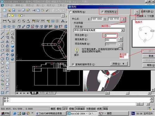
第九步:阵列

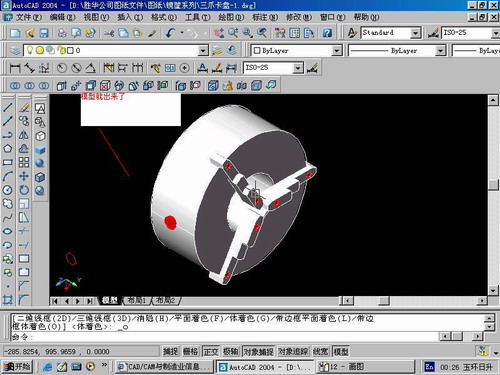
第10步.模型就完成了

来一张利用矢量处理的图片

说明:补充资料仅用于学习参考,请勿用于其它任何用途。
参考词条