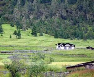
1) the lower Lulang river


鲁朗河下游
1.
Taking the lower Lulang river section as an example, the characters of water damage to roadbed along rivers,damage condition of old prevention measures is analyzed in the gorges of southeast of Tibet, and the design method of combining ferroconcrete apron with retaining wall is put forward.
川藏公路水毁危害严重,本文以鲁朗河下游段为例,分析了藏东南高山峡谷区沿河公路水毁特点,原防护工程被毁状况,并提出钢丝网混凝土护坦、扣墙相结合的改建工程设计,为山区沿河公路路基防护工程建设提供了依据。
2) lower Weihe River


渭河下游
1.
Auto-regulating function of channel of Lower Weihe River since 1960;


1960年以来渭河下游河道的自动调整作用
2.
Stable lowering of Tongguan bed elevation and comprehensive regulation of the lower Weihe River;
潼关高程的稳定降低与渭河下游河道综合治理
3) lower reaches of Yellow River


黄河下游
1.
Protective countermeasures of wetland natural reserve areas in lower reaches of Yellow River;
黄河下游沿岸湿地自然保护区的保护对策
2.
Engineering geological problems of foundation pits of floodgates in the lower reaches of Yellow River;
黄河下游涵闸基坑的主要工程地质问题
3.
Research on compensation policy for beach area in lower reaches of Yellow River;


黄河下游滩区运用补偿政策研究
4) lower reaches of Tarim river


塔河下游
1.
The river course at the lower reaches of Tarim river has cut off for twenty years.


2 0 0 1年 4月 1日第 3次向塔河下游输水 ,并确保向下游输水 3亿m3至台特玛湖 ,对此分析了紧急调水后塔河下游生态环境的改善情
5) lower Yellow River


黄河下游
1.
Historical sediment-related disasters in the lower Yellow River in relation with drainage basin factors (Ⅰ): influence of climate and vegetation;
黄河下游历史泥沙灾害的宏观特征及其与流域因素及人类活动的关系(Ⅰ)──历史气候及植被因素的影响
2.
Historical sediment-related disasters in the lower Yellow River in relation with drainage basin factors(Ⅱ): influence of human activities, earthquakes and landforms;
黄河下游历史泥沙灾害的宏观特征及其与流域因素和人类活动的关系(Ⅱ)──人类活动、历史地震及地形因子的影响
3.
Processes and characteristics of recent channel adjustment in the Lower Yellow River;


近期黄河下游河床调整过程及特点
6) lower course of Weihe River


渭河下游
1.
In the history,the super and large floods happen in the lower course of Weihe River for many times,so to bring about the serious disasters in the region.
历史上,渭河下游发生多次超大型洪水,给该地区带来了严重的灾害。
补充资料:鲁朗林海

鲁朗林海
鲁朗,藏语意为“龙王谷”,也是“叫人不想家”的地方。鲁朗海拔3700米,位于距八一镇80公里左右的川藏路上,坐落在深山老林之中;这是一片典型高原山地草甸狭长地带,长约15公里,平均宽约1公里。两侧青山由低往高分别由灌木丛和崐茂密的云杉和松树组成“鲁朗林海”;中间是整齐划一的草甸,崐犹如人工整治一般;草甸中,溪流蜿蜒,泉水潺潺,草坪上报春崐花、紫苑花、草梅花、马先蒿花等成千上万种野花怒放盛开,颇崐具林区特色的木篱笆、木板屋、木头桥及农牧民的村寨星落棋布、崐错落有秩,勾画了一幅恬静、优美的“山居图”。夏季,清风吹崐拂,翻起金色的麦浪;秋冬季节,鲁朗除了山腰的松树青葱不凋,崐两侧山脚的树叶由绿变黄,再由黄变红,弥漫满天的红霞。举目辽望,蔚蓝的天空中,白云飘飘,时而象奔驰的骏马,时而又恰似高原上的牦牛;时而呼啸而去,时而又闲庭信步,象少女婀娜多姿,象小伙热情奔放。
远处,皑皑白雪婉如厚厚的棉花,温暖地滋润着座座裸露的山峰;绵延起伏的山丘上,覆盖着一层嫩绿的草甸,大草甸中零星点缀着藏式民居,牛羊在草甸上悠然自得,咀嚼着可口的青草,戏嬉追逐。在这里,山间的云雾时聚时散,与雪山、林海、田畴构成一幅梦幻般的图画。还是人大副委员长崐蒋正华说得好,“雪山林海,云涛彩霞,一岭四季,十里九景,生态优美,资源丰富,沃野万顷,清泉百转。”置身于这鸟语花香的景区,晃若到了“神仙居住的地方 ”。
说明:补充资料仅用于学习参考,请勿用于其它任何用途。