1) Buha River Basin

布哈河流域
1.
Application of SWAT model to analysis of runoff variation of Buha River Basin of Qinghai Lake;
SWAT模型在青海湖布哈河流域径流变化成因分析中的应用
2) Buerhatong basin
布尔哈通河流域
3) Habahe valley
哈巴河流域
1.
The results showed that the topography and landforms of Habahe valley was a typical example of Hengduan Mountains.
结果认为 :哈巴河流域地形地貌在横断山区具有典型性 ,可按高山山地景观和中山山地与河谷景观进行功能分区。
4) Laohahe river basin
老哈河流域
1.
Variations of hydrological elements in Laohahe River Basin
老哈河流域水文要素变化研究
2.
Using monthly runoff data at Hongshan reservoir dam in Laohahe river basin,and through a variety of trend analysis,the characteristics and trend of runoff in the basin was examined.
利用老哈河流域红山水库坝址处1961—2000年逐月径流资料,采用M-K等多种趋势分析方法,检验了流域径流的变化特征及演变趋势。
3.
Based on the standards of classification and gradation of soil erosion issued by Ministry of Water Resource PRC,the soil erosion and its temporal-spatial evolution of the Laohahe river basin in the years of 1990 and 2000 were investigated with remote sensing(RS) and geographic information system(GIS) techniques.
应用RS和GIS技术,依据水利部颁发标准(SL190—96),对辽宁省境内老哈河流域1990年和2000年的土壤侵蚀状况及其时空变化进行了研究。
5) Tabu river basin
塔布河流域
1.
The role of seasonal river in the evolution of desertification in semi arid region: taking Tabu river basin of Inner Mongolia as an example;
半干旱区季节性河流在荒漠化发育中的作用——以内蒙古四子王旗塔布河流域为例
6) Buha river
布哈河
1.
Buha river is one of the main water resource of Qingai lake,drainage area is 135.
布哈河是青海湖的主要的水源之一,流域面积135。
补充资料:阿尔山市哈拉哈河
阿尔山市哈拉哈河
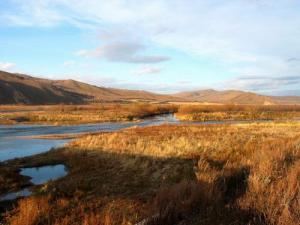
哈拉哈河发源于大兴安岭西侧摩天岭北部的达尔滨 湖,弯弯曲曲流入贝尔湖。全长399.5公里,境内长135公里,沿途有12条河流汇入,河面逐渐加宽,最宽可达80米,水深平均2米,流速每秒1-2立方米,河西岸比东岸高,有的地方在东岸一侧看不到西岸的情况。“哈拉哈”是蒙古语像,意为“屏障”,从河东岸看西岸如同一座长长的壁障在眼前,哈拉哈河由此地貌而得名。本地人又称这条河为“爱国河”“母亲河”,因为哈拉哈河是一条国际流,源于中国,流经蒙古就像一位远嫁异乡的姑娘,在国外漂泊半世,临末了又转身回到祖国的怀抱中。
哈拉哈河岸丛生着原始的植物群落,蜿蜒的河水隐没在高山峻岭之间。人们悠闲的在河岸上垂钓,在开满鲜花的草甸上漫步。在哈拉哈河中、下游河段还可以乘木筏顺河漂流,充分领略大自然的风采。
说明:补充资料仅用于学习参考,请勿用于其它任何用途。