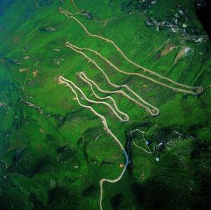
1) aerial photo
航拍
1.
The urban struc- ture that forms the regional environment is quantitatively analyzed rising fractal dimensional analyses of a 3-dimension shaded pic- ture, an aerial photo, and a 3-dimension model.
构成区域环境的城市结构以三维因子分析来进行量化分析,此3项因子为:三维的阴影图、航拍图和立体模型。
2) aerial images
航拍图像
1.
Taking into account characteristic of the UAV aerial images,this paper present a wavelet-based multiresolution analysis hierarchical scheme for image matching.
采用图像匹配辅助导航方法可以极大地提高无人机的作战和生存能力,文中结合无人机航拍图像的特点提出了基于小波多分辨率分析的图像匹配方法。
2.
The UAV aerial images have fine resolution.
无人机航拍图像具有很高分辨率 ,如何提取主要特征并降低计算代价是无人机图像匹配辅助导航的主要问题。
3.
Many experiments show that this method can recognize the runways of the airports exactly and quickly in the aerial images.
提出了一种用于在航拍图像中自动识别机场跑道的方法。
3) aerial video
航拍图像
1.
This paper realized a location system which locates moving-objects in aerial video.
针对航拍图像序列中运动目标使用仿射模型来描述航拍图像序列中的背景运动 ,提出了一种基于稀疏采样的局部补偿误差函数泰勒展开算法 ,该算法能有效地估计出模型参数 ;又根据图象序列中背景运动与目标运动的矢量不一致的特点 ,采用矢量聚类的算法 ,实现了对多个目标的准确定位 。
4) aerial camera
航拍相机
1.
Currently the frame rate of most aerial cameras based on full frame CCD FTF4052 is less than 1 f/s.
目前采用高分辨率全帧CCD FTF4052作图像传感器的航拍相机帧频一般不超过1f/s,不能满足高帧频应用。
5) aerial image
航拍图像
1.
Brings forward multiscale edge detecting method by using cubic B-Spline wavelet transform on aerial image.
作者提出了使用三次B样条小波对航拍图像进行多尺度边缘检测方法,介绍了小波及三次B样条函数的性质,根据Canny的3个最佳边缘准则和检测对象的特点,设计了B样条小波检测算法,把不同尺度下得到的边缘图像进行多尺度聚焦,输出检测目标边缘图像。
2.
In the field of military scouting, analysis is often carried by superposingaerial image on digital map; sometimes slant correction isrequiredto superpose correctly.
在军事侦察等领域,经常通过把航拍图像叠加在数字地图上进行分析,为了能准确地进行叠加,有时需要对航空图像进行倾斜校正。
6) aerial image
航拍影像
1.
, the 3-dimensional coordinate data, by the large-scale aerial image.
本文研究的目标是利用数字摄影测量技术及图形图像处理技术,从大比例尺航拍影像中,计算被摄物体的地形信息(即空间三维坐标)。
参考词条
补充资料:航拍

航拍
航拍(aerial photography)是指从空中拍摄地球地貌,获得俯视图。航拍图能够清晰的表现地理形态,因此除了作为摄影艺术的一环之外,也被运用于军事、交通建设、水利工程、生态研究、城市规划等方面。
说明:补充资料仅用于学习参考,请勿用于其它任何用途。