1) GM Model


GM模型
1.
Impacts of forest and precipitation on runoff and sediment in Tianshui watershed and GM models.;
渫水流域森林和降水量的变化对径流及泥沙影响分析和GM模型
2.
SPUC-system on predicting uranium concentration based on GM model of gray system theory is developed,and the mathematical model,constitution,function and theory foundation of this system are introduced.
基于灰色系统理论GM模型研制浸出液铀浓度预测系统SPUC,并介绍了本系统建立的数学模型、构成、功能和理论基础。
3.
Applying the grey system theory and topological selection with GM model, the corresponding GM(1.
运用灰色系统理论及GM模型拓朴选择,建立了相应的GM(1,1)模型,运用于运量预测,并以港口吞吐量与货物周转量的预测为例进行校验。
2) Grey Model


GM模型
4) GM(1,1) model


GM(1,1)模型
1.
Improved GM(1,1) Model and Its Application


改进的GM(1,1)模型及其应用
2.
New type of data transformation and its application in GM(1,1) model


一种新型数据变换技术及其在GM(1,1)模型中的应用
3.
The application of Gray GM(1,1) model and Verhulst model in the forecast of farmland in the karst area——A case in Bijie ecological experimental area
灰色GM(1,1)模型和Verhulst模型在喀斯特地区耕地预测中的应用——以毕节生态试验区为例
5) GM(1,1)model


GM(1,1)模型
1.
31%,with obviously high accuracy of prediction than GM(1,1)model.


在此基础上,运用灰色系统理论建立灰色不等维递补GM(1,h)模型对6个站的年ET0进行了模拟预测,并与灰色GM(1,1)模型进行了比较。
2.
Finally,the investment of 32 Hdesigned projects is estimated by GM(1,1)model in grey foresting method.
其原理是:首先选取典型工程建立特征元素的隶属函数,其次采用判断矩阵法确定各特征元素的权重,并通过计算典型工程与拟建工程的贴近度选出相似工程,最后运用灰色预测理论的GM(1,1)模型对拟建工程的投资进行估算。
3.
GM(1,1)model is amended by season exponent and is applied to forecast air quality in Zhengzhou,the application examples show the effectiveness in the time series prediction with a seasonal change.
在GM(1,1)模型基础上建立季节指数修正GM(1,1)模型,并应用到郑州市空气质量预测中,应用实例表明,该模型对含有季节变动因素的时间序列的预测,具有较好的效果。
6) GM(1,1)


GM(1,1)模型
1.
A Demand Forecasting Model for the Civilian Vehicle of Henan Based on GM(1,1)Model


基于GM(1,1)模型的河南省民用汽车需求预测模型
2.
Then coastline change forecast model established series GM(1,1) models based on vector coastline data,origin and accuracy value which were input by user,and forecast coastline can be achieved by connecting a series forecast points smoothly.
以海岸线遥感影像为数据,通过八邻域法海岸线边缘提取及矢量化、海岸线相关因子计算两个功能模块的处理,基于GM(1,1)模型的海岸线变化趋势预测模块对输入的四期矢量海岸线数据建立GM(1,1)模型,根据用户输入的预测原点和预测精度,得到若干预测点,继而得到预测的海岸线轮廓。
补充资料:AutoCad 教你绘制三爪卡盘模型,借用四视图来建模型
小弟写教程纯粹表达的是建模思路,供初学者参考.任何物体的建摸都需要思路,只有思路多,模型也就水到渠成.ok废话就不说了.建议使用1024X768分辨率
开始
先看下最终效果

第一步,如图所示将窗口分为四个视图

第二步,依次选择每个窗口,在分别输入各自己的视图

第三步,建立ucs重新建立世界坐标体系,捕捉三点来确定各自的ucs如图

第四步,初步大致建立基本模型.可以在主视图建立两个不同的圆,在用ext拉升,在用差集运算.如图:

第五步:关键一步,在此的我思路是.先画出卡爪的基本投影,在把他进行面域,在进行拉升高度分别是10,20,30曾t形状.如图:

第六步:画出螺栓的初步形状.如图

第七步:利用ext拉升圆,在拉升内六边形.注意拉升六边行时方向与拉升圆的方向是相反的.
之后在利用差集运算


第八步:将所得内螺栓模型分别复制到卡爪上,在利用三个视图调到与卡爪的中心对称.效果如图红色的是螺栓,最后是差集

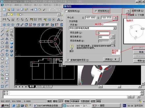
第九步:阵列

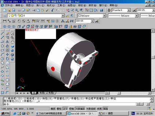
第10步.模型就完成了

来一张利用矢量处理的图片

说明:补充资料仅用于学习参考,请勿用于其它任何用途。
参考词条