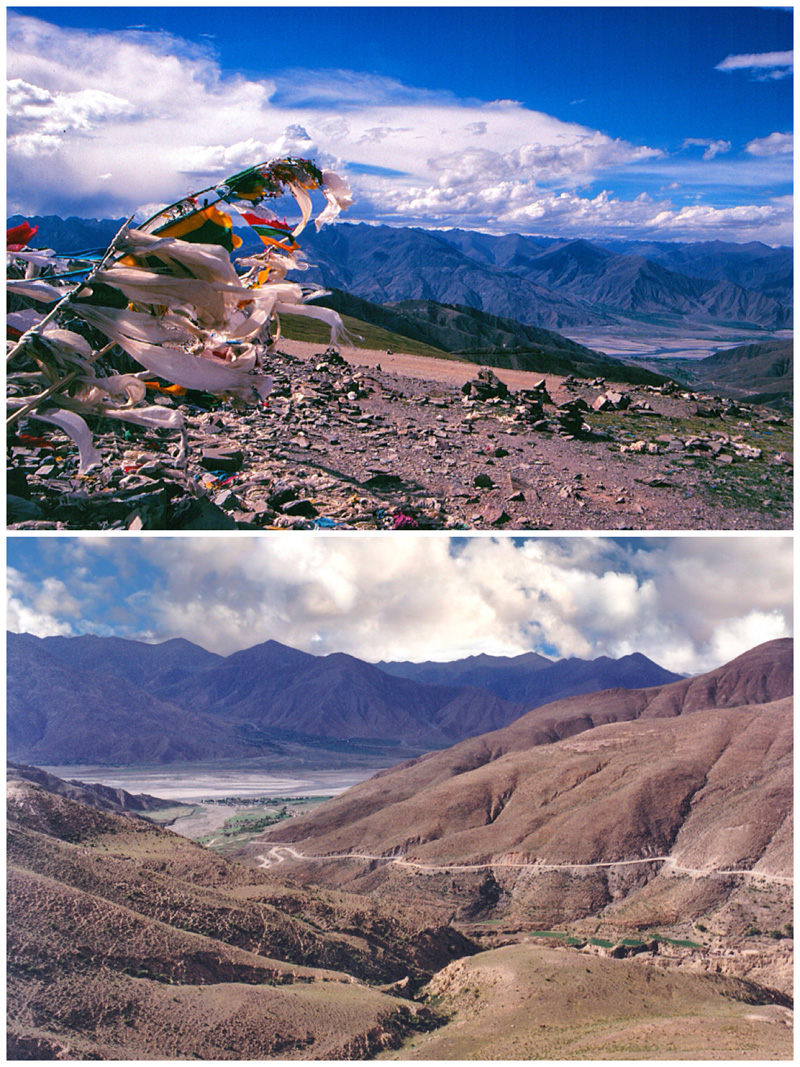
Kamb-la Pass looking towards Yarlung Tsangpo River 2000.
[Photo by Bruce Connolly/chinadaily.com.cn]
During my first week in Tibet autonomous region back in 2000, I noticed, and appreciated, the modern facilities in cities such as Lhasa and Xigaze. While there was much still steeped in tradition, the amenities for visitors were welcoming, particularly after several days traversing often unpaved roads.
Xigaze connects with Lhasa via the Northern Friendship Highway (G318), partly cut from cliffs along the Yarlung Tsangpo River. For many years however, indeed for centuries, the primary route connecting the cities involved a much longer journey along some magnificent and dramatic landscapes. Towards Lhasa the historic Southern Friendship Highway (S204/S307) initially follows the agriculturally rich Nyangchu Valley, a major grain producer for Tibet.
Family homes were often quite salubrious, with electricity provided by local hydro plants. The contrast between the well-irrigated green valley and its surrounding dry brown slopes was stark. For an hour, as atmospheric Tibetan mountain music played in the SUV, I sat back and watched the landscape unfold in front of me. With many villages scattered throughout the area, it seemed full of life. Children headed to school on donkey-hauled carts and yaks and goats were herded by women in heavy traditional dress.
But there were also signs of change. Alongside new schools, hotels had opened or were under construction. I became increasingly aware of the area's potential appeal to tourists: on the hillsides there sat not only small monasteries but also the remains of several earthen-walled forts, one seemingly stretching along a ridge. Having travelled 80 kilometers outside Xigaze, one of Tibet's more fascinating settlements, Gyangze, lay ahead.
Dramatic scenery above Gyangze. Mount Nojin Kangstan 2000.
[Photo by Bruce Connolly/chinadaily.com.cn]
To me it seemed to have retained the feel of a small town. Lying astride historic trade routes with Lhasa, much of the older town, partly surrounded by a three-kilometer-long wall, showed little modernity. Over many centuries yak caravans carried bags of wool and sheepskins from northern parts of Tibet to Gyangze for onward transfer south beyond the Himalayas. Looking closely, you could still see Nepalese influence in the architecture.
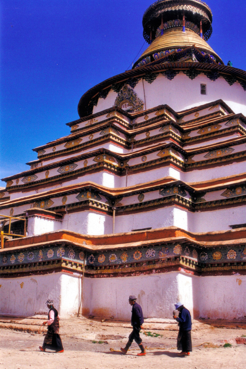
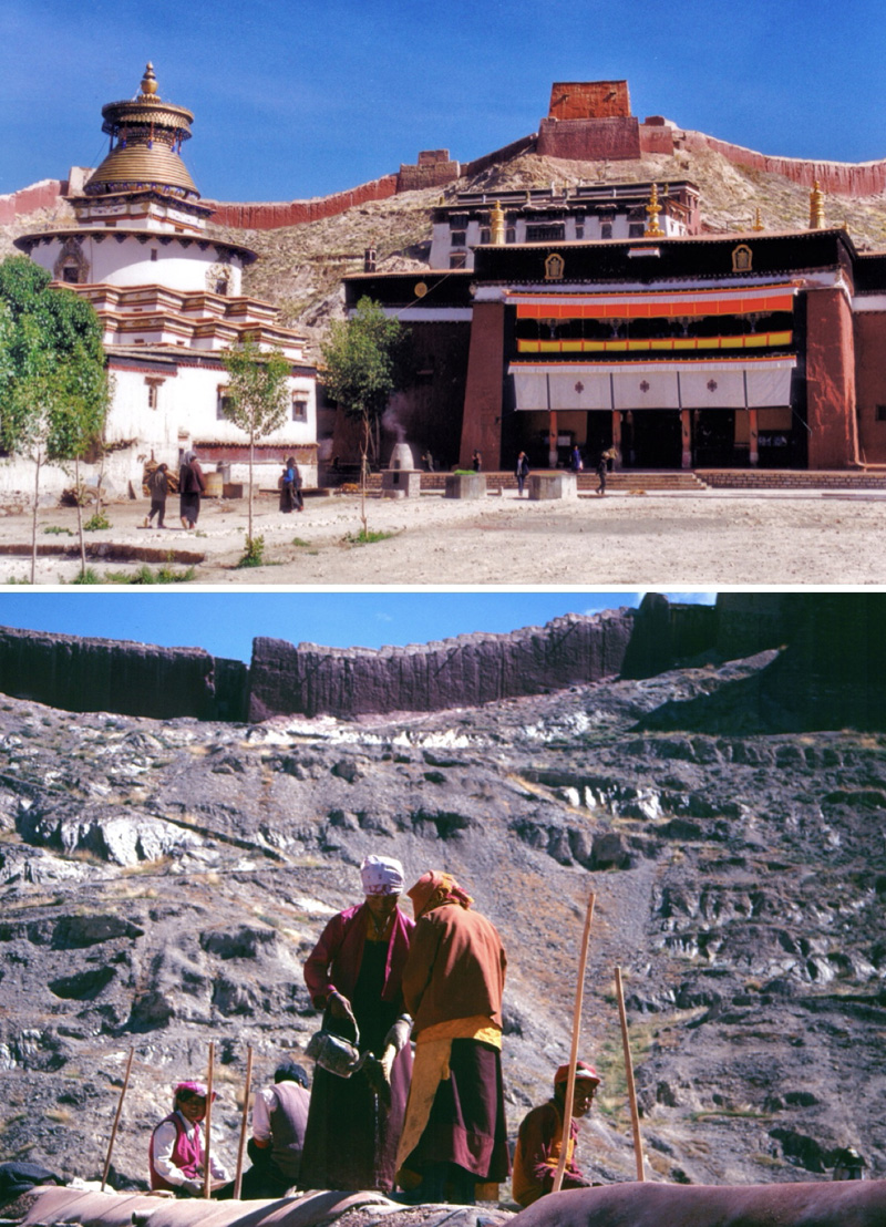
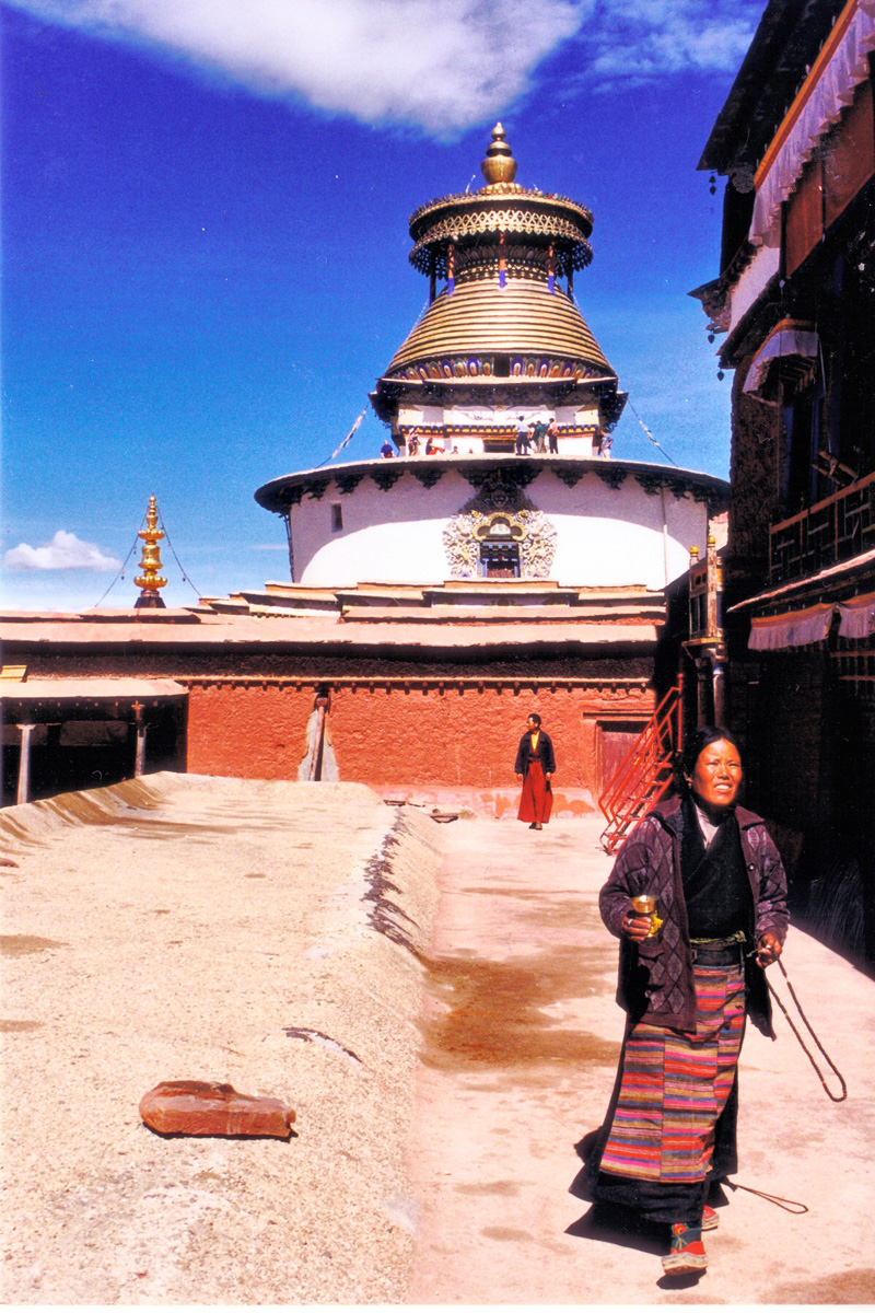
Palcho Monastery sits below a rocky ridge partly enclosing the town. Established in 1427, combining pagodas and temples, it nestles within a sprawling courtyard. Entering the Three Buddha Hall, I came upon several intricate sand paintings spread across the floor. Looking at the detail I thought of the time and skill involved in creating such artworks. Passing through a main hall lit by flickering butter lamps, an aroma of incense created an almost soporific atmosphere. Monks sat on carpeted benches chanting, banging cymbals while reciting sutras. A colorful drum rested on an equally colorful stand. Passing a room holding racks of books more than 500 years old, I climbed wooden stairs leading up to the roof, which revealed a fabulous sight.
Across from me rose one of Tibet's most magnificent and well-preserved architectural treasures, the Gyangze Kumbum or Palace of One Hundred Thousand Images. It's a multi-storied, gilded chorten or stupa, built in a Newari style, similar to one constructed in Kathmandu. Commissioned in 1427, it rises over four symmetrical floors topped by a gilded tower with its four sets of all-seeing eyes gazing out over the cardinal compass points. Climbing through different levels of the structure, I emerged to discover a stunning view of the surrounding area. I was also fascinated watching and listening to local workers restoring a rooftop, singing in unison.
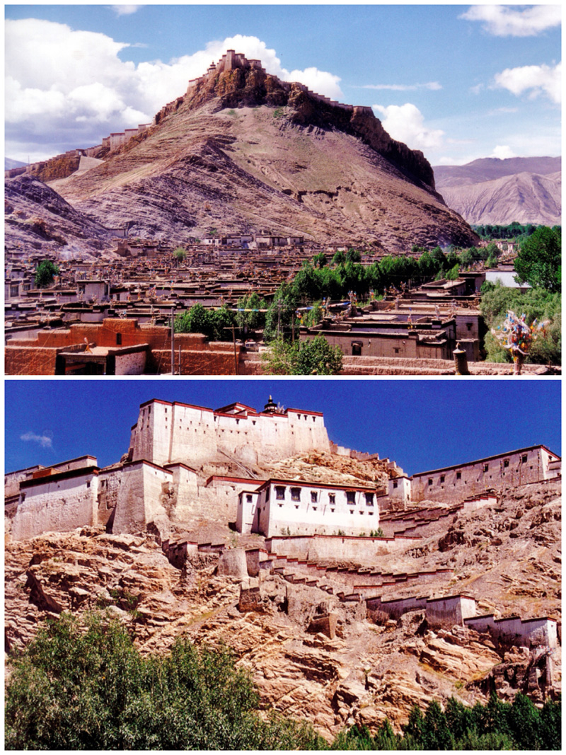
Gyangze Fort (dzong) and town 2000.
[Photo by Bruce Connolly/chinadaily.com.cn]
Overlooking everything was the 14th century Gyangze Dzong, one of the grandest fortresses in Tibet. It's a cornerstone of regional history, which was practically destroyed during the British invasion in 1904.
Exploring the town, I felt I could've stayed for weeks. Most buildings retained the traditional local style of two floors, white walls and blue window frames. There were few motor vehicles, rather horse-pulled carts passing tethered cows and open-air markets displaying large tea pots, kettles, cooking cauldrons, milk containers, and iron stoves. Children passed, going to and from school, as I headed for lunch in a delightful restaurant displaying paintings of the surrounding landscape. I loved the food, which had a distinctive Nepalese flavor.
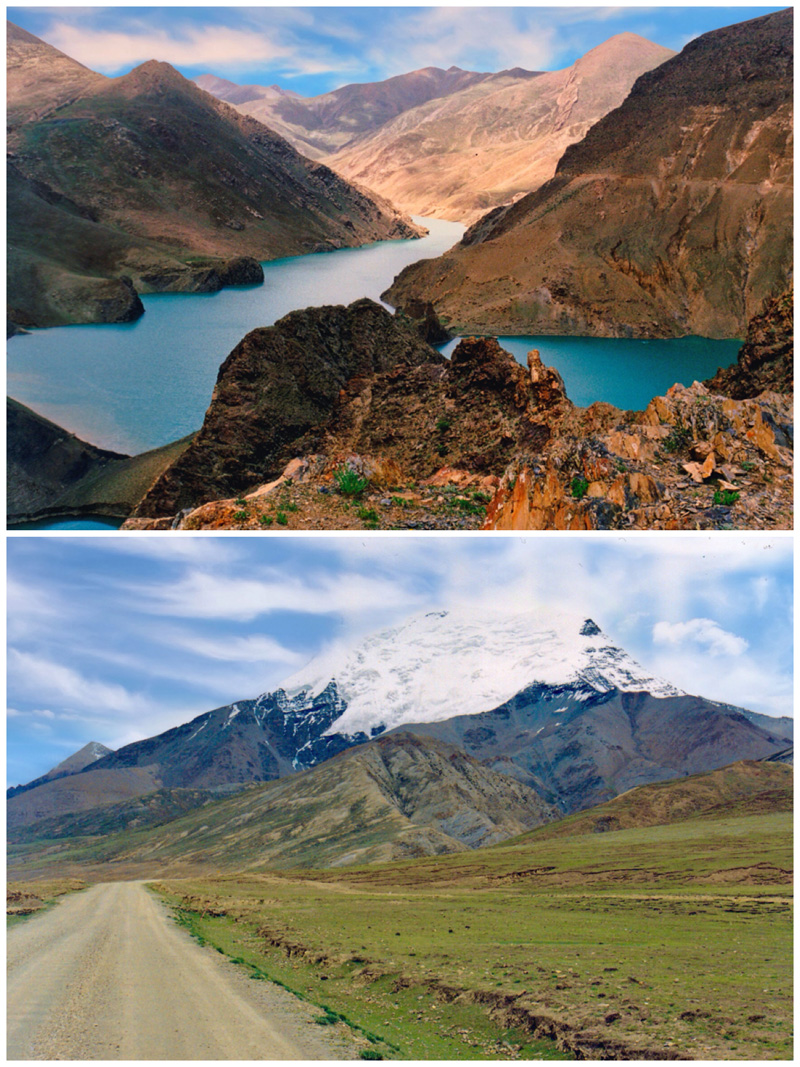
Departing Gyangze the scenery turned dramatic. Reaching a hydro power station, the road zigzagged steeply to emerge above a lake created by hydro dam construction. It was amazing to view this landscape of bare brownish rock rising above the blue waters from which an abandoned castle protruded.
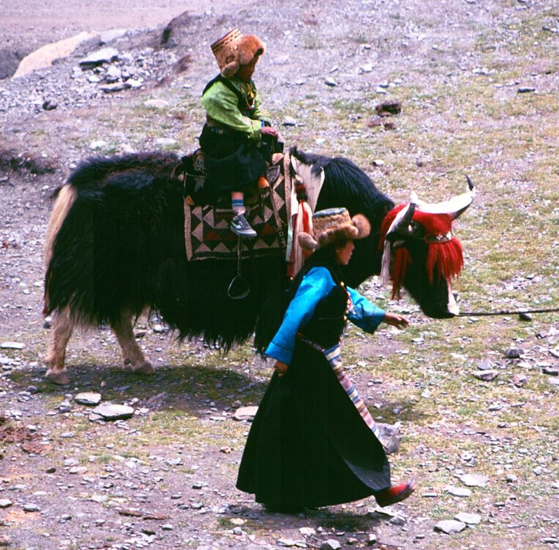
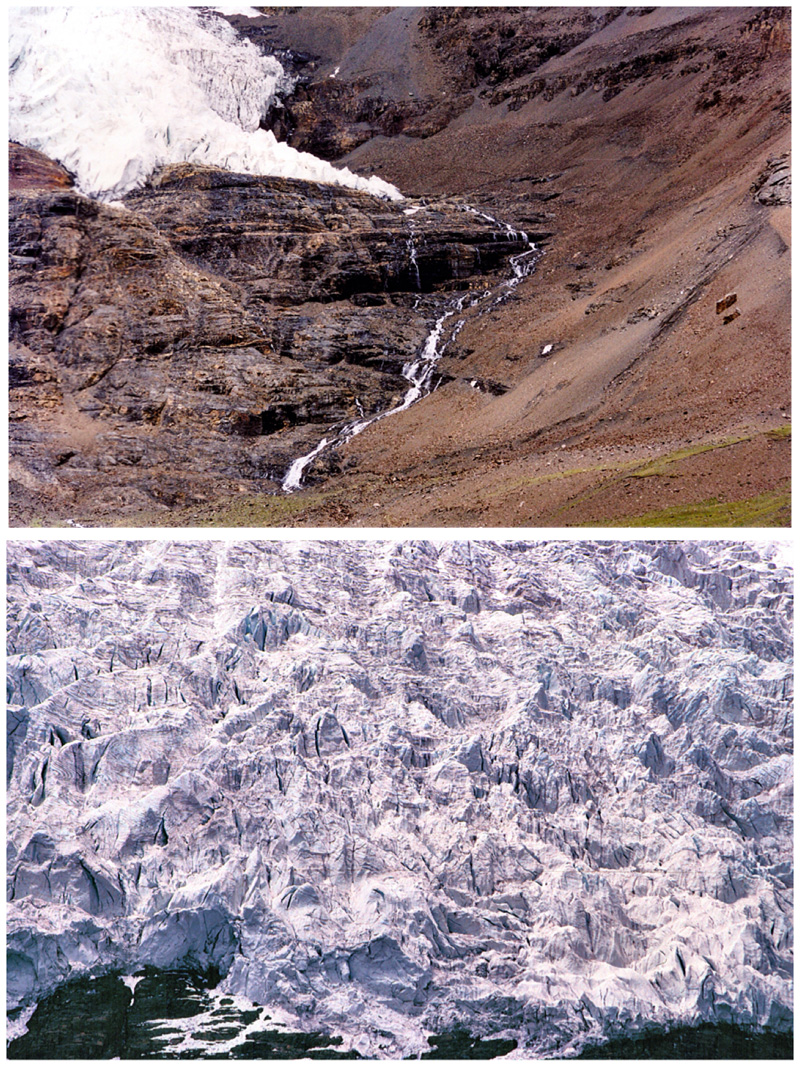
Distinct from the road earlier leading from Gyangze from Xigaze, this highway was very quiet. At first we would only see the occasional horse-drawn cart. Snow peaks started to appear ahead with the 7,191-metre-high, ice-covered Nojin Kangstan seeming to be directly above the highway. Yaks roamed while I, as a geographer, was just thrilled – this was a classical glacial geomorphology landscape.
Gyangze Kumbum 2000.
[Photo by Bruce Connolly/chinadaily.com.cn]
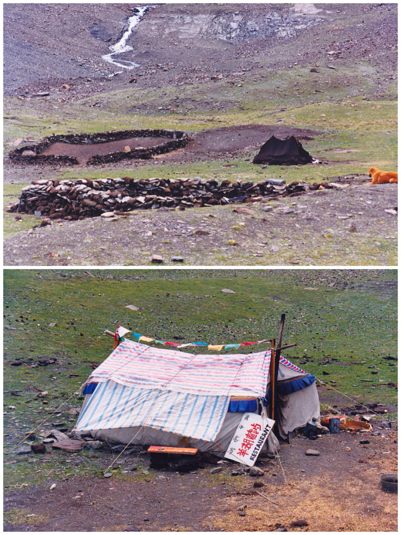
The 5,045-meter-high Karo La Pass was the highest point. There the mouth of a glacier, cracked into deep crevasses, clung to rocks above a small, semi-nomadic encampment. Stopping there I sat on a rock while looking at features I had studied and written about during my university days. I was also quietly amused at how the locals had turned a tent into a restaurant for occasional passing tourists, while also selling polished stones and beads.
Again, sad to leave, the road started descending an equally impressive u-shaped valley, passing slopes of shattered rock, pierced by crashing meltwater streams. I was enthralled by the scene. As the land started leveling out, we rounded a bend to see the calm waters of Yamzho Yumco, its name deriving from its turquoise color. As we crossed a plain passing through Nagarze, a small lake-side town, snowy mountains formed the backdrop. A modern middle school sat among primarily traditional highland architecture.
Sitting there for a few moments, looking across the expanse of the lake, one of the three largest sacred lakes in Tibet, I was momentarily taken back to the western coasts and islands of my homeland, Scotland. The waters blue, the hills green. The flocks of sheep grazing by the waterside contributed to these thoughts. Looking closer however I saw the dark tents of the pastoralists, some of whom came over, curious at the sight of me staring across the landscape.
As we slowly wound around the lake shores with its sweeping bays and grand vistas, it seemed difficult to imagine that this had been the main highway from Lhasa westwards. It was so quiet and peaceful. I had found another Shangri-La within myself, again the desire to spend time, just taking in nature. It was a stunning landscape enhanced by the now-distant snowy mountains.
A few small villages sat close to the road, some with small local temples adorned with prayer flags, – prayer flags were also placed along parts of the shoreline. Packhorse trains were gathered up, preparing to head to remote, road-less communities. I noticed small ferries crossing to the far shores.
Gyangze Palcho Monastery and roof renovation work 2000.
[Photo by Bruce Connolly/chinadaily.com.cn]
A long gradual climb now commenced and with each bend of the road, as we moved higher, the views across the tranquil waters of the lake became increasingly spectacular. The road was winding up towards the 4,794-meter-high Kamb-la Pass, where we stopped to take in the views. Stretching below were the waters of the lake and in the distance, mountain summits rose. As I looked to the north, we seemed roughly at the same elevation of many peaks. It really did feel as though I was standing on the roof of the world.
As I sat at the pass, cars and buses ascended the slope, stopping to throw out sutras onto the stones around the prayer flags. I saw this at most high passes we crossed. Then there would be the long descent back towards the Yamzho Yumco. My descent however would eventually lead northwards down to the Yarlung Tsangpo River, whose waters I could see from my high vantage point. In the distance there was the valley leading back towards Lhasa.
The road then was narrow, at times with vertigo-inducing drops. After some time I was glad when we started reaching villages before arriving at the wide braided channel of the river and the main road connecting Lhasa with Gonggar Airport. The Southern Friendship Highway had been a magnificent road trip.
Gyangze street scenes 2000.
[Photo by Bruce Connolly/chinadaily.com.cn]
Children with yak at Karo-la Pass 2000.
[Photo by Bruce Connolly/chinadaily.com.cn]
Encampment and 'restaurant' at Karl-la Pass 2000.
[Photo by Bruce Connolly/chinadaily.com.cn]
Glacial scenery at Karo-la Pass 2000.
[Photo by Bruce Connolly/chinadaily.com.cn]
On roof of Palcho Monastery Gyangze 2000.
[Photo by Bruce Connolly/chinadaily.com.cn]